You are here: Home > Network List > CI - Caltech Regional Seismic Network Stations List
> Station SWS Sam W. Stewart, Westmorland, CA, USA > Earthquake Result Viewer
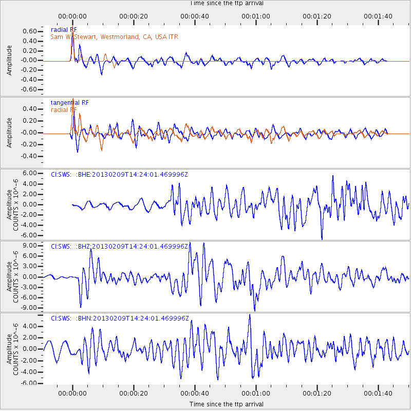
SWS Sam W. Stewart, Westmorland, CA, USA - Earthquake Result Viewer
*The percent match for this event was below the threshold and hence no stack was calculated.
| Earthquake location: |
Colombia |
| Earthquake latitude/longitude: |
1.1/-77.4 |
| Earthquake time(UTC): |
2013/02/09 (040) 14:16:07 GMT |
| Earthquake Depth: |
145 km |
| Earthquake Magnitude: |
6.7 MB, 6.9 MW, 6.9 MW |
| Earthquake Catalog/Contributor: |
WHDF/NEIC |
|
| Network: |
CI Caltech Regional Seismic Network |
| Station: |
SWS Sam W. Stewart, Westmorland, CA, USA |
| Lat/Lon: |
32.94 N/115.80 W |
| Elevation: |
140 m |
|
| Distance: |
48.0 deg |
| Az: |
315.315 deg |
| Baz: |
123.27 deg |
| Ray Param: |
$rayparam |
*The percent match for this event was below the threshold and hence was not used in the summary stack. |
|
| Radial Match: |
87.71332 % |
| Radial Bump: |
400 |
| Transverse Match: |
79.92552 % |
| Transverse Bump: |
400 |
| SOD ConfigId: |
494114 |
| Insert Time: |
2013-05-01 09:21:57.683 +0000 |
| GWidth: |
2.5 |
| Max Bumps: |
400 |
| Tol: |
0.001 |
|
Signal To Noise
| Channel | StoN | STA | LTA |
| CI:SWS: :BHZ:20130209T14:24:01.469996Z | 6.225507 | 3.0887552E-6 | 4.9614516E-7 |
| CI:SWS: :BHN:20130209T14:24:01.469996Z | 1.2622913 | 1.1014291E-6 | 8.725633E-7 |
| CI:SWS: :BHE:20130209T14:24:01.469996Z | 2.722217 | 1.4746388E-6 | 5.4170505E-7 |
| Arrivals |
| Ps | |
| PpPs | |
| PsPs/PpSs | |


