You are here: Home > Network List > GT - Global Telemetered Seismograph Network (USAF/USGS) Stations List
> Station BOSA Boshof, South Africa > Earthquake Result Viewer
BOSA Boshof, South Africa - Earthquake Result Viewer
| Earthquake location: |
Myanmar |
| Earthquake latitude/longitude: |
26.9/97.2 |
| Earthquake time(UTC): |
2000/06/07 (159) 21:46:55 GMT |
| Earthquake Depth: |
33 km |
| Earthquake Magnitude: |
6.3 MB, 6.5 MS, 6.4 MW, 6.4 MW |
| Earthquake Catalog/Contributor: |
WHDF/NEIC |
|
| Network: |
GT Global Telemetered Seismograph Network (USAF/USGS) |
| Station: |
BOSA Boshof, South Africa |
| Lat/Lon: |
28.61 S/25.26 E |
| Elevation: |
1280 m |
|
| Distance: |
88.3 deg |
| Az: |
236.767 deg |
| Baz: |
58.202 deg |
| Ray Param: |
0.042612795 |
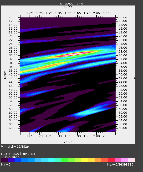
| Estimated Moho Depth: |
29.0 km |
| Estimated Crust Vp/Vs: |
1.89 |
| Assumed Crust Vp: |
6.459 km/s |
| Estimated Crust Vs: |
3.413 km/s |
| Estimated Crust Poisson's Ratio: |
0.31 |
|
| Radial Match: |
92.5826 % |
| Radial Bump: |
284 |
| Transverse Match: |
79.16496 % |
| Transverse Bump: |
391 |
| SOD ConfigId: |
3744 |
| Insert Time: |
2010-02-27 01:44:55.744 +0000 |
| GWidth: |
2.5 |
| Max Bumps: |
400 |
| Tol: |
0.001 |
|
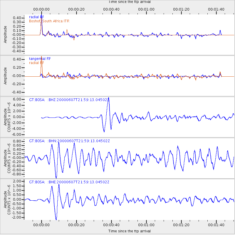
Signal To Noise
| Channel | StoN | STA | LTA |
| GT:BOSA: :BHN:20000607T21:59:13.04502Z | 0.93439126 | 1.2330308E-7 | 1.3196086E-7 |
| GT:BOSA: :BHE:20000607T21:59:13.04502Z | 0.72732764 | 1.13481576E-7 | 1.560254E-7 |
| GT:BOSA: :BHZ:20000607T21:59:13.04502Z | 2.183823 | 3.8299953E-7 | 1.7538028E-7 |
| Arrivals |
| Ps | 4.1 SECOND |
| PpPs | 13 SECOND |
| PsPs/PpSs | 17 SECOND |


