You are here: Home > Network List > GT - Global Telemetered Seismograph Network (USAF/USGS) Stations List
> Station BOSA Boshof, South Africa > Earthquake Result Viewer
BOSA Boshof, South Africa - Earthquake Result Viewer
| Earthquake location: |
Southern Sumatra, Indonesia |
| Earthquake latitude/longitude: |
-4.6/102.1 |
| Earthquake time(UTC): |
2000/06/04 (156) 16:39:45 GMT |
| Earthquake Depth: |
33 km |
| Earthquake Magnitude: |
6.7 MB |
| Earthquake Catalog/Contributor: |
WHDF/NEIC |
|
| Network: |
GT Global Telemetered Seismograph Network (USAF/USGS) |
| Station: |
BOSA Boshof, South Africa |
| Lat/Lon: |
28.61 S/25.26 E |
| Elevation: |
1280 m |
|
| Distance: |
76.2 deg |
| Az: |
241.814 deg |
| Baz: |
87.798 deg |
| Ray Param: |
0.051076747 |
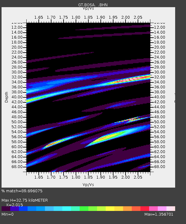
| Estimated Moho Depth: |
32.75 km |
| Estimated Crust Vp/Vs: |
2.02 |
| Assumed Crust Vp: |
6.459 km/s |
| Estimated Crust Vs: |
3.206 km/s |
| Estimated Crust Poisson's Ratio: |
0.34 |
|
| Radial Match: |
89.696075 % |
| Radial Bump: |
400 |
| Transverse Match: |
76.60677 % |
| Transverse Bump: |
400 |
| SOD ConfigId: |
3744 |
| Insert Time: |
2010-02-27 01:44:57.449 +0000 |
| GWidth: |
2.5 |
| Max Bumps: |
400 |
| Tol: |
0.001 |
|
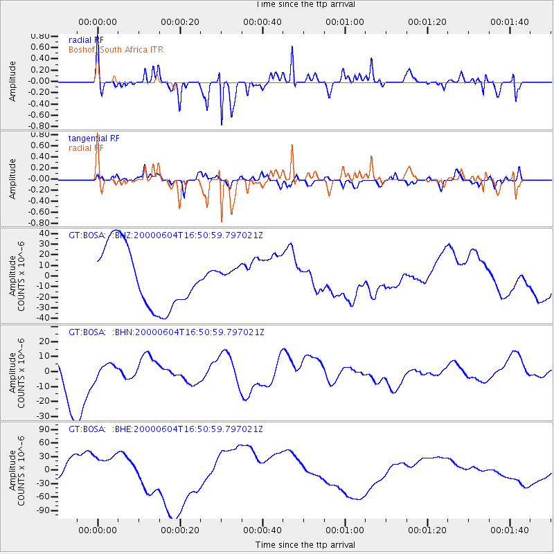
Signal To Noise
| Channel | StoN | STA | LTA |
| GT:BOSA: :BHN:20000604T16:50:59.797021Z | 0.32253435 | 4.301536E-6 | 1.3336676E-5 |
| GT:BOSA: :BHE:20000604T16:50:59.797021Z | 1.4563733 | 3.197507E-5 | 2.195527E-5 |
| GT:BOSA: :BHZ:20000604T16:50:59.797021Z | 0.32697928 | 9.343298E-6 | 2.8574588E-5 |
| Arrivals |
| Ps | 5.3 SECOND |
| PpPs | 15 SECOND |
| PsPs/PpSs | 20 SECOND |


