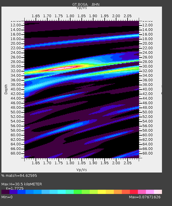
BOSA Boshof, South Africa - Earthquake Result Viewer
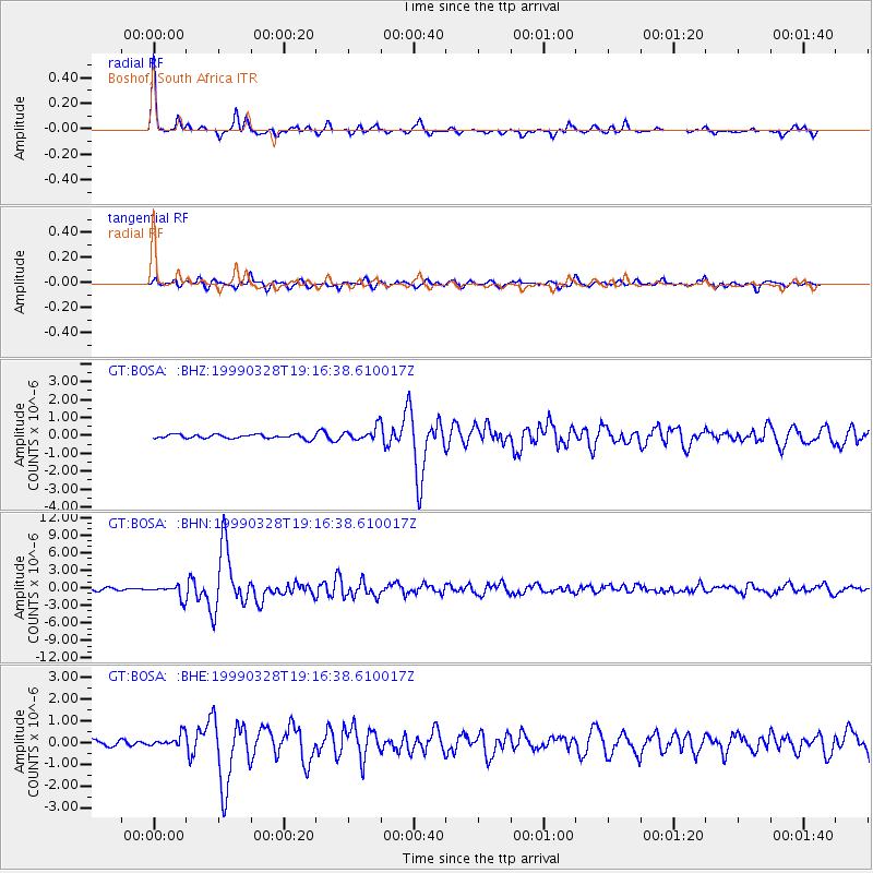
Earthquake location: Western Xizang-India Border Reg.
Earthquake latitude/longitude: 30.5/79.4
Earthquake time(UTC): 1999/03/28 (087) 19:05:11 GMT
Earthquake Depth: 15 km
Earthquake Magnitude: 6.4 MB, 6.6 MS, 6.6 MW, 6.5 ME
Earthquake Catalog/Contributor: WHDF/NEIC
Network: GT Global Telemetered Seismograph Network (USAF/USGS)
Station: BOSA Boshof, South Africa
Lat/Lon: 28.61 S/25.26 E
Elevation: 1280 m
Distance: 78.2 deg
Az: 226.71 deg
Baz: 45.6 deg
Ray Param: 0.049763512
Estimated Moho Depth: 30.5 km
Estimated Crust Vp/Vs: 1.77
Assumed Crust Vp: 6.459 km/s
Estimated Crust Vs: 3.644 km/s
Estimated Crust Poisson's Ratio: 0.27
Radial Match: 94.62595 %
Radial Bump: 227
Transverse Match: 78.95407 %
Transverse Bump: 400
SOD ConfigId: 4480
Insert Time: 2010-02-27 01:45:02.314 +0000
GWidth: 2.5
Max Bumps: 400
Tol: 0.001

Signal To Noise

ChannelStoNSTALTA
GT:BOSA: :BHN:19990328T19:16:38.610017Z3.424931.1083744E-63.2361953E-7
GT:BOSA: :BHE:19990328T19:16:38.610017Z1.68040312.7890823E-71.6597697E-7
GT:BOSA: :BHZ:19990328T19:16:38.610017Z3.47354753.9007776E-71.1229953E-7
Arrivals
Ps3.8 SECOND
PpPs13 SECOND
PsPs/PpSs16 SECOND