You are here: Home > Network List > CI - Caltech Regional Seismic Network Stations List
> Station SLA SLA, Trona, CA, USA > Earthquake Result Viewer
SLA SLA, Trona, CA, USA - Earthquake Result Viewer
| Earthquake location: |
New Ireland Region, P.N.G. |
| Earthquake latitude/longitude: |
-5.1/153.2 |
| Earthquake time(UTC): |
2000/11/16 (321) 05:47:34 GMT |
| Earthquake Depth: |
33 km |
| Earthquake Magnitude: |
5.6 MB |
| Earthquake Catalog/Contributor: |
WHDF/NEIC |
|
| Network: |
CI Caltech Regional Seismic Network |
| Station: |
SLA SLA, Trona, CA, USA |
| Lat/Lon: |
35.89 N/117.28 W |
| Elevation: |
1174 m |
|
| Distance: |
92.6 deg |
| Az: |
54.369 deg |
| Baz: |
265.565 deg |
| Ray Param: |
0.04142024 |
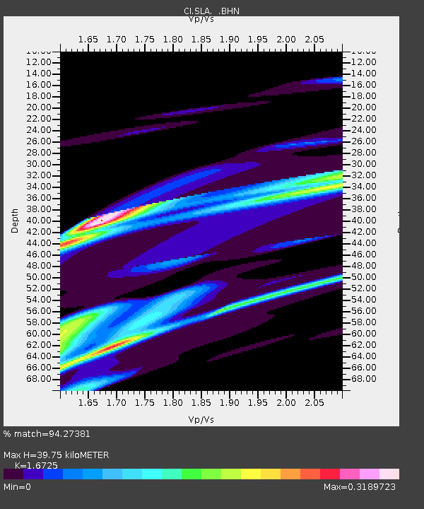
| Estimated Moho Depth: |
39.75 km |
| Estimated Crust Vp/Vs: |
1.67 |
| Assumed Crust Vp: |
6.276 km/s |
| Estimated Crust Vs: |
3.752 km/s |
| Estimated Crust Poisson's Ratio: |
0.22 |
|
| Radial Match: |
94.27381 % |
| Radial Bump: |
372 |
| Transverse Match: |
95.984215 % |
| Transverse Bump: |
262 |
| SOD ConfigId: |
3770 |
| Insert Time: |
2010-02-25 20:27:26.667 +0000 |
| GWidth: |
2.5 |
| Max Bumps: |
400 |
| Tol: |
0.001 |
|
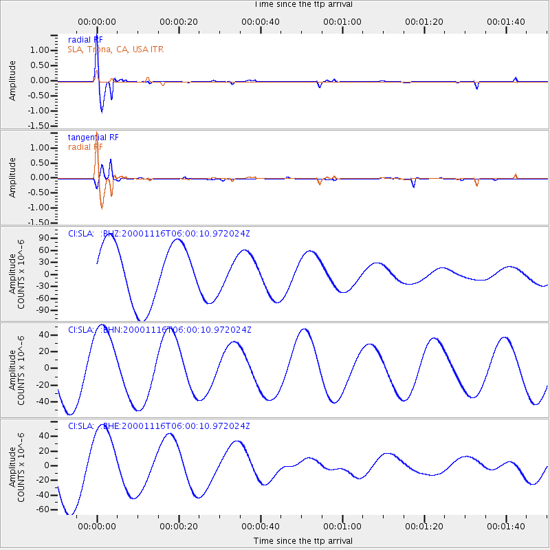
Signal To Noise
| Channel | StoN | STA | LTA |
| CI:SLA: :BHN:20001116T06:00:10.972024Z | 1.2443609 | 4.758814E-5 | 3.8243033E-5 |
| CI:SLA: :BHE:20001116T06:00:10.972024Z | 0.78473485 | 4.828275E-5 | 6.152747E-5 |
| CI:SLA: :BHZ:20001116T06:00:10.972024Z | 0.5471745 | 3.9281407E-5 | 7.178954E-5 |
| Arrivals |
| Ps | 4.3 SECOND |
| PpPs | 17 SECOND |
| PsPs/PpSs | 21 SECOND |


