You are here: Home > Network List > TA - USArray Transportable Network (new EarthScope stations) Stations List
> Station Q24A Divide, CO, USA > Earthquake Result Viewer
Q24A Divide, CO, USA - Earthquake Result Viewer

| Earthquake location: |
Colombia |
| Earthquake latitude/longitude: |
1.1/-77.4 |
| Earthquake time(UTC): |
2013/02/09 (040) 14:16:07 GMT |
| Earthquake Depth: |
145 km |
| Earthquake Magnitude: |
6.7 MB, 6.9 MW, 6.9 MW |
| Earthquake Catalog/Contributor: |
WHDF/NEIC |
|
| Network: |
TA USArray Transportable Network (new EarthScope stations) |
| Station: |
Q24A Divide, CO, USA |
| Lat/Lon: |
38.96 N/105.15 W |
| Elevation: |
2775 m |
|
| Distance: |
45.4 deg |
| Az: |
329.345 deg |
| Baz: |
139.166 deg |
| Ray Param: |
0.07077441 |
| Estimated Moho Depth: |
50.25 km |
| Estimated Crust Vp/Vs: |
1.77 |
| Assumed Crust Vp: |
6.159 km/s |
| Estimated Crust Vs: |
3.47 km/s |
| Estimated Crust Poisson's Ratio: |
0.27 |
|
| Radial Match: |
89.499596 % |
| Radial Bump: |
400 |
| Transverse Match: |
78.086845 % |
| Transverse Bump: |
400 |
| SOD ConfigId: |
494114 |
| Insert Time: |
2013-05-01 09:33:23.481 +0000 |
| GWidth: |
2.5 |
| Max Bumps: |
400 |
| Tol: |
0.001 |
|
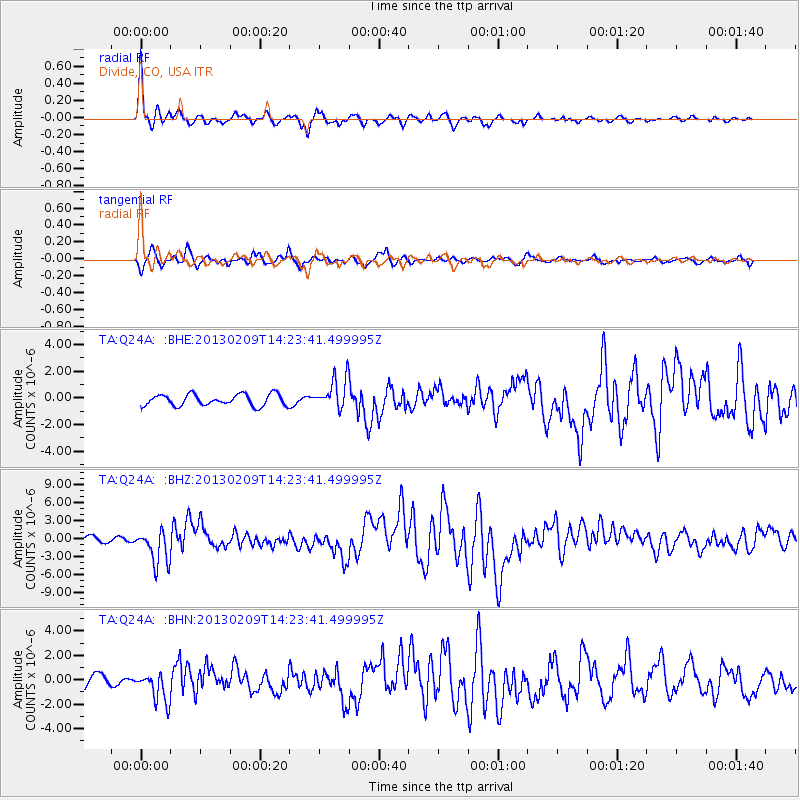
Signal To Noise
| Channel | StoN | STA | LTA |
| TA:Q24A: :BHZ:20130209T14:23:41.499995Z | 5.1725364 | 2.8846493E-6 | 5.5768567E-7 |
| TA:Q24A: :BHN:20130209T14:23:41.499995Z | 1.9596868 | 1.2467741E-6 | 6.3621087E-7 |
| TA:Q24A: :BHE:20130209T14:23:41.499995Z | 2.7514472 | 1.1636533E-6 | 4.229241E-7 |
| Arrivals |
| Ps | 6.7 SECOND |
| PpPs | 21 SECOND |
| PsPs/PpSs | 28 SECOND |


