You are here: Home > Network List > TA - USArray Transportable Network (new EarthScope stations) Stations List
> Station Y41A Eaglette Bearden, AR, USA > Earthquake Result Viewer
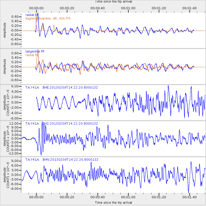
Y41A Eaglette Bearden, AR, USA - Earthquake Result Viewer
*The percent match for this event was below the threshold and hence no stack was calculated.
| Earthquake location: |
Colombia |
| Earthquake latitude/longitude: |
1.1/-77.4 |
| Earthquake time(UTC): |
2013/02/09 (040) 14:16:07 GMT |
| Earthquake Depth: |
145 km |
| Earthquake Magnitude: |
6.7 MB, 6.9 MW, 6.9 MW |
| Earthquake Catalog/Contributor: |
WHDF/NEIC |
|
| Network: |
TA USArray Transportable Network (new EarthScope stations) |
| Station: |
Y41A Eaglette Bearden, AR, USA |
| Lat/Lon: |
33.88 N/92.61 W |
| Elevation: |
99 m |
|
| Distance: |
35.6 deg |
| Az: |
337.944 deg |
| Baz: |
153.173 deg |
| Ray Param: |
$rayparam |
*The percent match for this event was below the threshold and hence was not used in the summary stack. |
|
| Radial Match: |
79.056244 % |
| Radial Bump: |
400 |
| Transverse Match: |
66.74757 % |
| Transverse Bump: |
400 |
| SOD ConfigId: |
494114 |
| Insert Time: |
2013-05-01 09:37:32.777 +0000 |
| GWidth: |
2.5 |
| Max Bumps: |
400 |
| Tol: |
0.001 |
|
Signal To Noise
| Channel | StoN | STA | LTA |
| TA:Y41A: :BHZ:20130209T14:22:20.800013Z | 5.586418 | 6.6142125E-6 | 1.1839809E-6 |
| TA:Y41A: :BHN:20130209T14:22:20.800013Z | 1.7236916 | 2.9865726E-6 | 1.7326605E-6 |
| TA:Y41A: :BHE:20130209T14:22:20.800013Z | 0.8972005 | 1.4091406E-6 | 1.5705972E-6 |
| Arrivals |
| Ps | |
| PpPs | |
| PsPs/PpSs | |


