You are here: Home > Network List > TA - USArray Transportable Network (new EarthScope stations) Stations List
> Station L41A Preston, IA, USA > Earthquake Result Viewer
L41A Preston, IA, USA - Earthquake Result Viewer
| Earthquake location: |
Colombia |
| Earthquake latitude/longitude: |
1.1/-77.4 |
| Earthquake time(UTC): |
2013/02/09 (040) 14:16:07 GMT |
| Earthquake Depth: |
145 km |
| Earthquake Magnitude: |
6.7 MB, 6.9 MW, 6.9 MW |
| Earthquake Catalog/Contributor: |
WHDF/NEIC |
|
| Network: |
TA USArray Transportable Network (new EarthScope stations) |
| Station: |
L41A Preston, IA, USA |
| Lat/Lon: |
42.08 N/90.50 W |
| Elevation: |
238 m |
|
| Distance: |
42.4 deg |
| Az: |
345.511 deg |
| Baz: |
160.367 deg |
| Ray Param: |
0.072651066 |
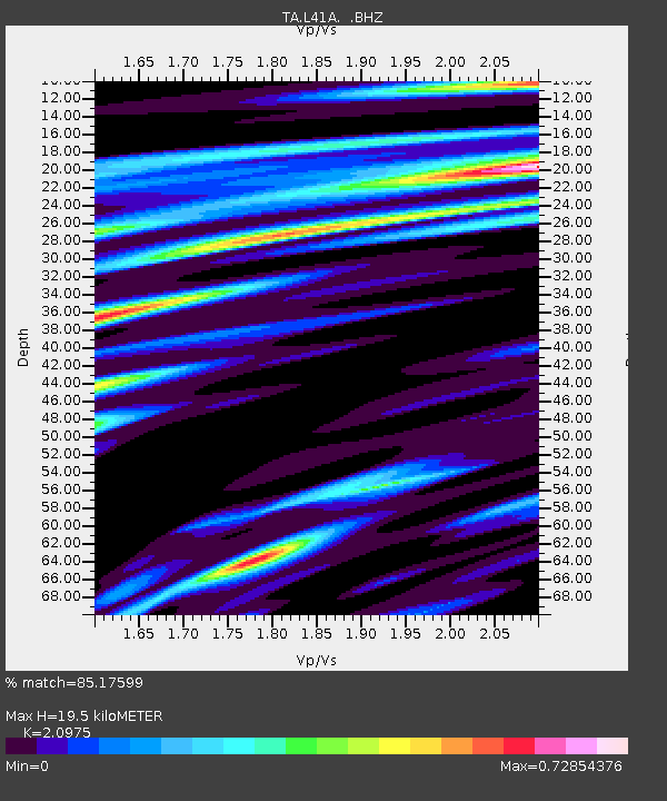
| Estimated Moho Depth: |
19.5 km |
| Estimated Crust Vp/Vs: |
2.10 |
| Assumed Crust Vp: |
6.53 km/s |
| Estimated Crust Vs: |
3.113 km/s |
| Estimated Crust Poisson's Ratio: |
0.35 |
|
| Radial Match: |
85.17599 % |
| Radial Bump: |
364 |
| Transverse Match: |
62.739834 % |
| Transverse Bump: |
400 |
| SOD ConfigId: |
494114 |
| Insert Time: |
2013-05-01 09:38:55.092 +0000 |
| GWidth: |
2.5 |
| Max Bumps: |
400 |
| Tol: |
0.001 |
|

Signal To Noise
| Channel | StoN | STA | LTA |
| TA:L41A: :BHZ:20130209T14:23:17.825007Z | 7.688819 | 8.54563E-6 | 1.1114361E-6 |
| TA:L41A: :BHN:20130209T14:23:17.825007Z | 6.3082933 | 4.580244E-6 | 7.2606707E-7 |
| TA:L41A: :BHE:20130209T14:23:17.825007Z | 2.0013685 | 1.5846762E-6 | 7.917963E-7 |
| Arrivals |
| Ps | 3.5 SECOND |
| PpPs | 8.7 SECOND |
| PsPs/PpSs | 12 SECOND |


