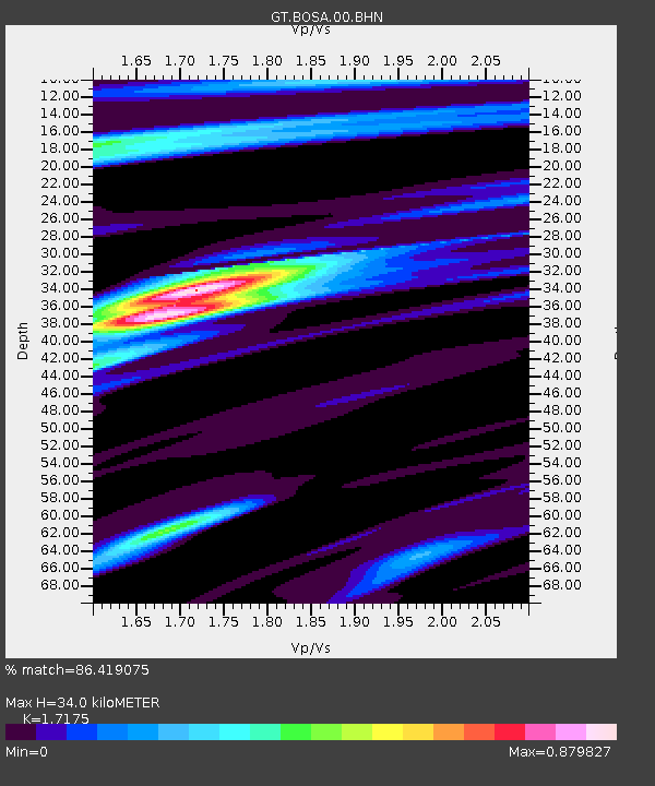
BOSA Boshof, South Africa - Earthquake Result Viewer
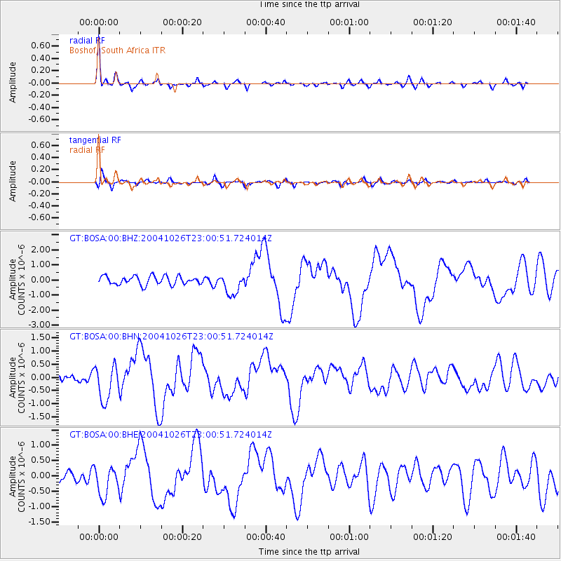
Earthquake location: South Sandwich Islands Region
Earthquake latitude/longitude: -57.1/-24.7
Earthquake time(UTC): 2004/10/26 (300) 22:53:07 GMT
Earthquake Depth: 10 km
Earthquake Magnitude: 5.6 MB, 6.3 MS, 6.4 MW, 6.2 MW
Earthquake Catalog/Contributor: WHDF/NEIC
Network: GT Global Telemetered Seismograph Network (USAF/USGS)
Station: BOSA Boshof, South Africa
Lat/Lon: 28.61 S/25.26 E
Elevation: 1280 m
Distance: 44.9 deg
Az: 72.37 deg
Baz: 216.301 deg
Ray Param: 0.071624264
Estimated Moho Depth: 34.0 km
Estimated Crust Vp/Vs: 1.72
Assumed Crust Vp: 6.459 km/s
Estimated Crust Vs: 3.761 km/s
Estimated Crust Poisson's Ratio: 0.24
Radial Match: 86.419075 %
Radial Bump: 368
Transverse Match: 55.88927 %
Transverse Bump: 357
SOD ConfigId: 2459
Insert Time: 2010-02-27 01:45:20.722 +0000
GWidth: 2.5
Max Bumps: 400
Tol: 0.001

Signal To Noise

ChannelStoNSTALTA
GT:BOSA:00:BHN:20041026T23:00:51.724014Z4.17139866.8475043E-71.6415369E-7
GT:BOSA:00:BHE:20041026T23:00:51.724014Z2.017974.807971E-72.382578E-7
GT:BOSA:00:BHZ:20041026T23:00:51.724014Z2.55729277.2262725E-72.8257512E-7
Arrivals
Ps4.0 SECOND
PpPs13 SECOND
PsPs/PpSs17 SECOND