You are here: Home > Network List > TA - USArray Transportable Network (new EarthScope stations) Stations List
> Station T47A Sharon Grove, KY, USA > Earthquake Result Viewer
T47A Sharon Grove, KY, USA - Earthquake Result Viewer
| Earthquake location: |
Colombia |
| Earthquake latitude/longitude: |
1.1/-77.4 |
| Earthquake time(UTC): |
2013/02/09 (040) 14:16:07 GMT |
| Earthquake Depth: |
145 km |
| Earthquake Magnitude: |
6.7 MB, 6.9 MW, 6.9 MW |
| Earthquake Catalog/Contributor: |
WHDF/NEIC |
|
| Network: |
TA USArray Transportable Network (new EarthScope stations) |
| Station: |
T47A Sharon Grove, KY, USA |
| Lat/Lon: |
36.99 N/87.11 W |
| Elevation: |
217 m |
|
| Distance: |
36.8 deg |
| Az: |
346.964 deg |
| Baz: |
163.641 deg |
| Ray Param: |
0.07598668 |
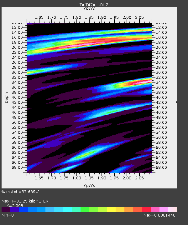
| Estimated Moho Depth: |
33.25 km |
| Estimated Crust Vp/Vs: |
2.10 |
| Assumed Crust Vp: |
6.444 km/s |
| Estimated Crust Vs: |
3.076 km/s |
| Estimated Crust Poisson's Ratio: |
0.35 |
|
| Radial Match: |
87.68941 % |
| Radial Bump: |
329 |
| Transverse Match: |
91.106926 % |
| Transverse Bump: |
249 |
| SOD ConfigId: |
494114 |
| Insert Time: |
2013-05-01 09:46:53.944 +0000 |
| GWidth: |
2.5 |
| Max Bumps: |
400 |
| Tol: |
0.001 |
|
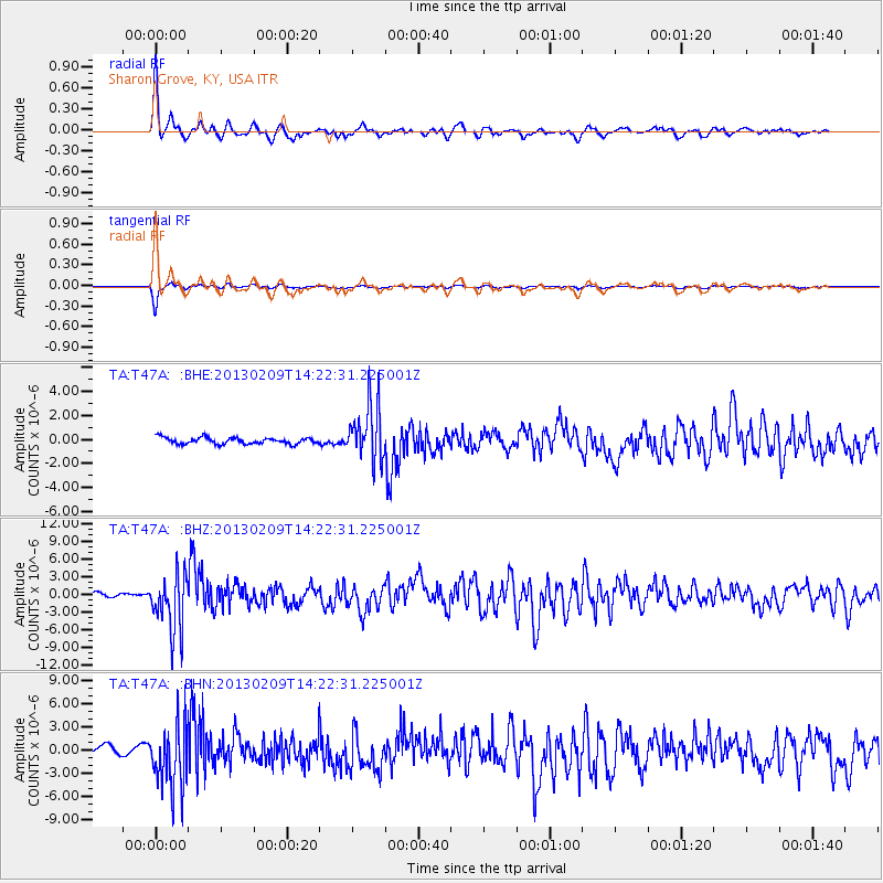
Signal To Noise
| Channel | StoN | STA | LTA |
| TA:T47A: :BHZ:20130209T14:22:31.225001Z | 9.137308 | 4.8324955E-6 | 5.288752E-7 |
| TA:T47A: :BHN:20130209T14:22:31.225001Z | 8.018624 | 4.213557E-6 | 5.2547136E-7 |
| TA:T47A: :BHE:20130209T14:22:31.225001Z | 8.689153 | 2.315293E-6 | 2.6645785E-7 |
| Arrivals |
| Ps | 6.0 SECOND |
| PpPs | 15 SECOND |
| PsPs/PpSs | 21 SECOND |


