You are here: Home > Network List > TA - USArray Transportable Network (new EarthScope stations) Stations List
> Station 150A Eclectic, AL, USA > Earthquake Result Viewer
150A Eclectic, AL, USA - Earthquake Result Viewer
| Earthquake location: |
Colombia |
| Earthquake latitude/longitude: |
1.1/-77.4 |
| Earthquake time(UTC): |
2013/02/09 (040) 14:16:07 GMT |
| Earthquake Depth: |
145 km |
| Earthquake Magnitude: |
6.7 MB, 6.9 MW, 6.9 MW |
| Earthquake Catalog/Contributor: |
WHDF/NEIC |
|
| Network: |
TA USArray Transportable Network (new EarthScope stations) |
| Station: |
150A Eclectic, AL, USA |
| Lat/Lon: |
32.61 N/86.02 W |
| Elevation: |
145 m |
|
| Distance: |
32.3 deg |
| Az: |
346.308 deg |
| Baz: |
163.716 deg |
| Ray Param: |
0.07826923 |
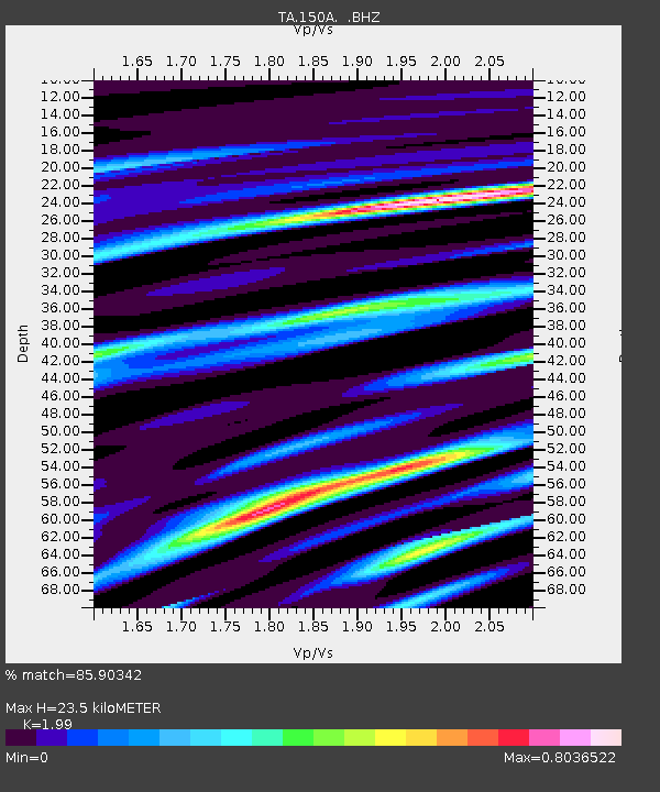
| Estimated Moho Depth: |
23.5 km |
| Estimated Crust Vp/Vs: |
1.99 |
| Assumed Crust Vp: |
6.565 km/s |
| Estimated Crust Vs: |
3.299 km/s |
| Estimated Crust Poisson's Ratio: |
0.33 |
|
| Radial Match: |
85.90342 % |
| Radial Bump: |
376 |
| Transverse Match: |
62.205307 % |
| Transverse Bump: |
400 |
| SOD ConfigId: |
494114 |
| Insert Time: |
2013-05-01 09:48:31.306 +0000 |
| GWidth: |
2.5 |
| Max Bumps: |
400 |
| Tol: |
0.001 |
|
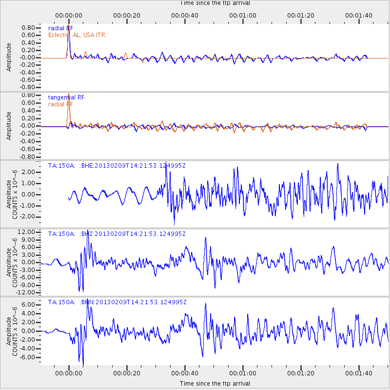
Signal To Noise
| Channel | StoN | STA | LTA |
| TA:150A: :BHZ:20130209T14:21:53.124995Z | 6.5405717 | 4.04282E-6 | 6.1811414E-7 |
| TA:150A: :BHN:20130209T14:21:53.124995Z | 5.4341154 | 2.4163448E-6 | 4.4466205E-7 |
| TA:150A: :BHE:20130209T14:21:53.124995Z | 2.3328135 | 9.002534E-7 | 3.8590886E-7 |
| Arrivals |
| Ps | 3.8 SECOND |
| PpPs | 10.0 SECOND |
| PsPs/PpSs | 14 SECOND |


