You are here: Home > Network List > TA - USArray Transportable Network (new EarthScope stations) Stations List
> Station 454A Quitman, GA, USA > Earthquake Result Viewer
454A Quitman, GA, USA - Earthquake Result Viewer
| Earthquake location: |
Colombia |
| Earthquake latitude/longitude: |
1.1/-77.4 |
| Earthquake time(UTC): |
2013/02/09 (040) 14:16:07 GMT |
| Earthquake Depth: |
145 km |
| Earthquake Magnitude: |
6.7 MB, 6.9 MW, 6.9 MW |
| Earthquake Catalog/Contributor: |
WHDF/NEIC |
|
| Network: |
TA USArray Transportable Network (new EarthScope stations) |
| Station: |
454A Quitman, GA, USA |
| Lat/Lon: |
30.71 N/83.63 W |
| Elevation: |
50 m |
|
| Distance: |
30.0 deg |
| Az: |
349.217 deg |
| Baz: |
167.455 deg |
| Ray Param: |
0.07918768 |
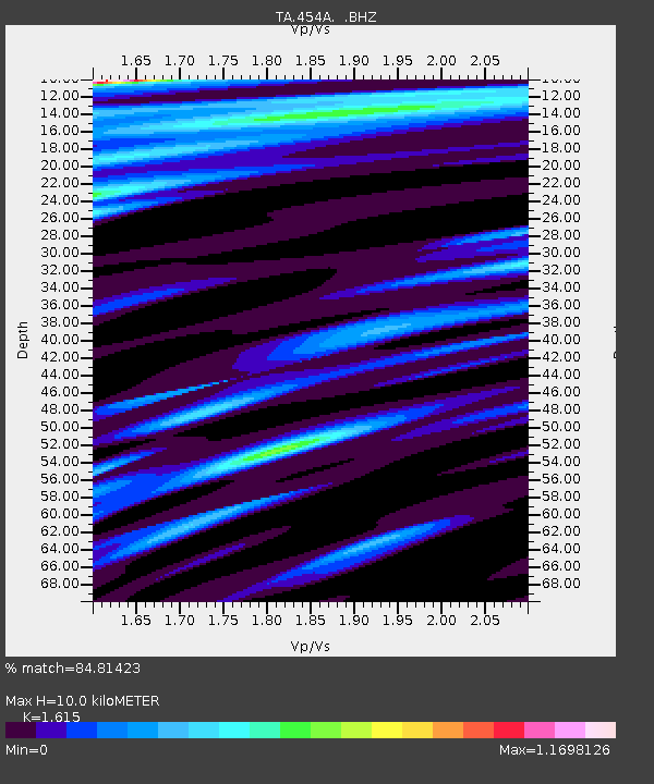
| Estimated Moho Depth: |
10.0 km |
| Estimated Crust Vp/Vs: |
1.62 |
| Assumed Crust Vp: |
6.565 km/s |
| Estimated Crust Vs: |
4.065 km/s |
| Estimated Crust Poisson's Ratio: |
0.19 |
|
| Radial Match: |
84.81423 % |
| Radial Bump: |
399 |
| Transverse Match: |
58.440613 % |
| Transverse Bump: |
400 |
| SOD ConfigId: |
494114 |
| Insert Time: |
2013-05-01 09:49:40.055 +0000 |
| GWidth: |
2.5 |
| Max Bumps: |
400 |
| Tol: |
0.001 |
|

Signal To Noise
| Channel | StoN | STA | LTA |
| TA:454A: :BHZ:20130209T14:21:32.700007Z | 4.598789 | 6.6842886E-6 | 1.4534888E-6 |
| TA:454A: :BHN:20130209T14:21:32.700007Z | 1.9419427 | 2.2567588E-6 | 1.162114E-6 |
| TA:454A: :BHE:20130209T14:21:32.700007Z | 1.8519107 | 1.8673466E-6 | 1.0083351E-6 |
| Arrivals |
| Ps | 1.0 SECOND |
| PpPs | 3.6 SECOND |
| PsPs/PpSs | 4.7 SECOND |


