You are here: Home > Network List > TA - USArray Transportable Network (new EarthScope stations) Stations List
> Station 252A Lumpkin, GA, USA > Earthquake Result Viewer
252A Lumpkin, GA, USA - Earthquake Result Viewer
| Earthquake location: |
Colombia |
| Earthquake latitude/longitude: |
1.1/-77.4 |
| Earthquake time(UTC): |
2013/02/09 (040) 14:16:07 GMT |
| Earthquake Depth: |
145 km |
| Earthquake Magnitude: |
6.7 MB, 6.9 MW, 6.9 MW |
| Earthquake Catalog/Contributor: |
WHDF/NEIC |
|
| Network: |
TA USArray Transportable Network (new EarthScope stations) |
| Station: |
252A Lumpkin, GA, USA |
| Lat/Lon: |
32.00 N/84.74 W |
| Elevation: |
142 m |
|
| Distance: |
31.5 deg |
| Az: |
347.994 deg |
| Baz: |
165.832 deg |
| Ray Param: |
0.07865161 |
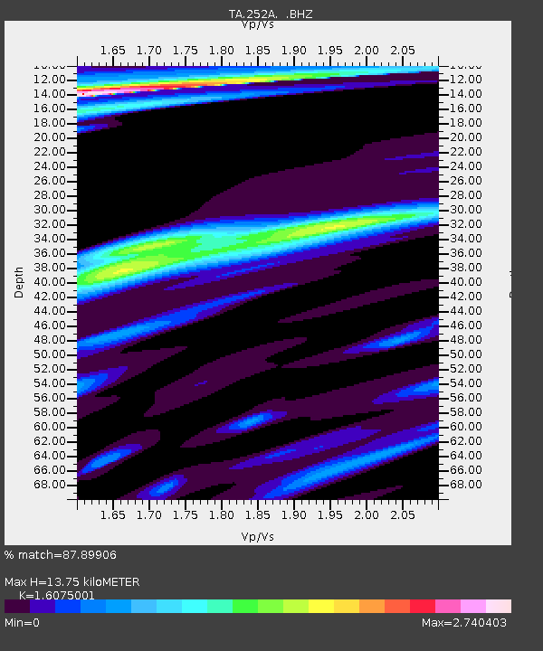
| Estimated Moho Depth: |
13.75 km |
| Estimated Crust Vp/Vs: |
1.61 |
| Assumed Crust Vp: |
6.347 km/s |
| Estimated Crust Vs: |
3.948 km/s |
| Estimated Crust Poisson's Ratio: |
0.18 |
|
| Radial Match: |
87.89906 % |
| Radial Bump: |
400 |
| Transverse Match: |
72.96557 % |
| Transverse Bump: |
398 |
| SOD ConfigId: |
494114 |
| Insert Time: |
2013-05-01 09:50:03.709 +0000 |
| GWidth: |
2.5 |
| Max Bumps: |
400 |
| Tol: |
0.001 |
|

Signal To Noise
| Channel | StoN | STA | LTA |
| TA:252A: :BHZ:20130209T14:21:45.499995Z | 21.54988 | 9.617686E-6 | 4.4629886E-7 |
| TA:252A: :BHN:20130209T14:21:45.499995Z | 2.5417922 | 3.6368117E-6 | 1.430806E-6 |
| TA:252A: :BHE:20130209T14:21:45.499995Z | 1.3496656 | 2.2201125E-6 | 1.6449351E-6 |
| Arrivals |
| Ps | 1.4 SECOND |
| PpPs | 5.2 SECOND |
| PsPs/PpSs | 6.6 SECOND |


