You are here: Home > Network List > TA - USArray Transportable Network (new EarthScope stations) Stations List
> Station 256A Glennville, GA, USA > Earthquake Result Viewer
256A Glennville, GA, USA - Earthquake Result Viewer
| Earthquake location: |
Colombia |
| Earthquake latitude/longitude: |
1.1/-77.4 |
| Earthquake time(UTC): |
2013/02/09 (040) 14:16:07 GMT |
| Earthquake Depth: |
145 km |
| Earthquake Magnitude: |
6.7 MB, 6.9 MW, 6.9 MW |
| Earthquake Catalog/Contributor: |
WHDF/NEIC |
|
| Network: |
TA USArray Transportable Network (new EarthScope stations) |
| Station: |
256A Glennville, GA, USA |
| Lat/Lon: |
31.98 N/81.89 W |
| Elevation: |
46 m |
|
| Distance: |
31.0 deg |
| Az: |
352.564 deg |
| Baz: |
171.242 deg |
| Ray Param: |
0.07886122 |
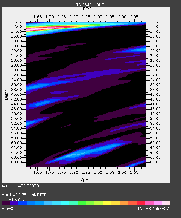
| Estimated Moho Depth: |
12.75 km |
| Estimated Crust Vp/Vs: |
1.64 |
| Assumed Crust Vp: |
5.989 km/s |
| Estimated Crust Vs: |
3.657 km/s |
| Estimated Crust Poisson's Ratio: |
0.20 |
|
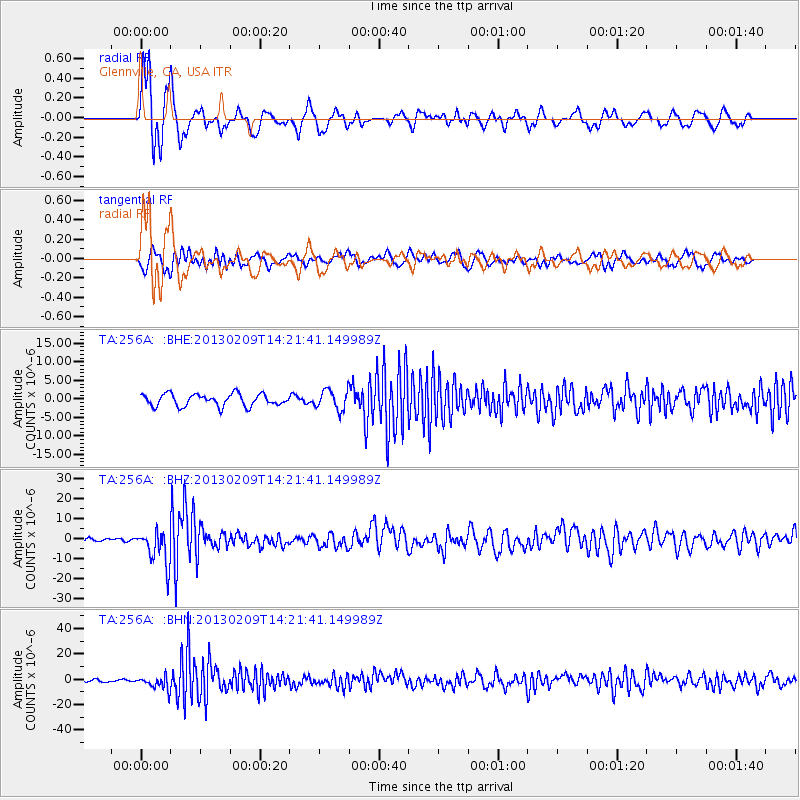
| Radial Match: |
88.22978 % |
| Radial Bump: |
400 |
| Transverse Match: |
64.538506 % |
| Transverse Bump: |
400 |
| SOD ConfigId: |
494114 |
| Insert Time: |
2013-05-01 09:50:28.581 +0000 |
| GWidth: |
2.5 |
| Max Bumps: |
400 |
| Tol: |
0.001 |
|
Signal To Noise
| Channel | StoN | STA | LTA |
| TA:256A: :BHZ:20130209T14:21:41.149989Z | 10.044364 | 8.696542E-6 | 8.658131E-7 |
| TA:256A: :BHN:20130209T14:21:41.149989Z | 4.5886674 | 5.0111094E-6 | 1.0920619E-6 |
| TA:256A: :BHE:20130209T14:21:41.149989Z | 1.6304036 | 2.6566668E-6 | 1.6294534E-6 |
| Arrivals |
| Ps | 1.5 SECOND |
| PpPs | 5.2 SECOND |
| PsPs/PpSs | 6.7 SECOND |


