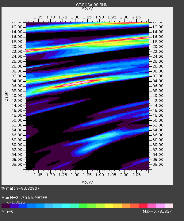
BOSA Boshof, South Africa - Earthquake Result Viewer
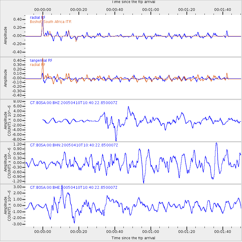
Earthquake location: Southern Sumatra, Indonesia
Earthquake latitude/longitude: -1.6/99.6
Earthquake time(UTC): 2005/04/10 (100) 10:29:11 GMT
Earthquake Depth: 19 km
Earthquake Magnitude: 6.4 MB, 6.7 MS, 6.7 MW, 6.6 MW
Earthquake Catalog/Contributor: WHDF/NEIC
Network: GT Global Telemetered Seismograph Network (USAF/USGS)
Station: BOSA Boshof, South Africa
Lat/Lon: 28.61 S/25.26 E
Elevation: 1280 m
Distance: 75.5 deg
Az: 240.99 deg
Baz: 83.868 deg
Ray Param: 0.05162022
Estimated Moho Depth: 34.75 km
Estimated Crust Vp/Vs: 1.80
Assumed Crust Vp: 6.459 km/s
Estimated Crust Vs: 3.584 km/s
Estimated Crust Poisson's Ratio: 0.28
Radial Match: 83.30907 %
Radial Bump: 283
Transverse Match: 63.92768 %
Transverse Bump: 400
SOD ConfigId: 2459
Insert Time: 2010-02-27 01:45:36.861 +0000
GWidth: 2.5
Max Bumps: 400
Tol: 0.001

Signal To Noise

ChannelStoNSTALTA
GT:BOSA:00:BHN:20050410T10:40:22.850007Z0.59970481.6172947E-72.696818E-7
GT:BOSA:00:BHE:20050410T10:40:22.850007Z2.2677059.230334E-74.0703415E-7
GT:BOSA:00:BHZ:20050410T10:40:22.850007Z3.3074781.7696225E-65.350368E-7
Arrivals
Ps4.5 SECOND
PpPs15 SECOND
PsPs/PpSs19 SECOND