You are here: Home > Network List > TA - USArray Transportable Network (new EarthScope stations) Stations List
> Station Z53A Monticello, GA, USA > Earthquake Result Viewer
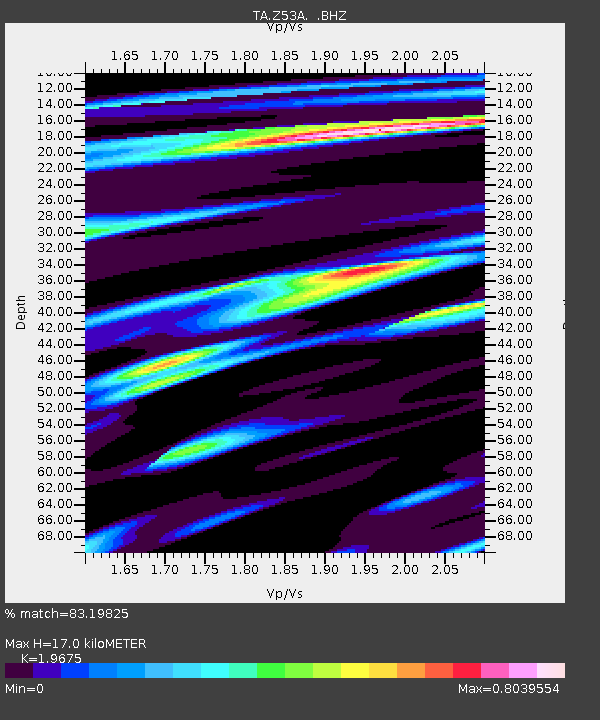
Z53A Monticello, GA, USA - Earthquake Result Viewer
| Earthquake location: |
Colombia |
| Earthquake latitude/longitude: |
1.1/-77.4 |
| Earthquake time(UTC): |
2013/02/09 (040) 14:16:07 GMT |
| Earthquake Depth: |
145 km |
| Earthquake Magnitude: |
6.7 MB, 6.9 MW, 6.9 MW |
| Earthquake Catalog/Contributor: |
WHDF/NEIC |
|
| Network: |
TA USArray Transportable Network (new EarthScope stations) |
| Station: |
Z53A Monticello, GA, USA |
| Lat/Lon: |
33.28 N/83.57 W |
| Elevation: |
144 m |
|
| Distance: |
32.5 deg |
| Az: |
350.34 deg |
| Baz: |
168.447 deg |
| Ray Param: |
0.078198 |
| Estimated Moho Depth: |
17.0 km |
| Estimated Crust Vp/Vs: |
1.97 |
| Assumed Crust Vp: |
6.565 km/s |
| Estimated Crust Vs: |
3.336 km/s |
| Estimated Crust Poisson's Ratio: |
0.33 |
|
| Radial Match: |
83.19825 % |
| Radial Bump: |
323 |
| Transverse Match: |
56.519836 % |
| Transverse Bump: |
400 |
| SOD ConfigId: |
494114 |
| Insert Time: |
2013-05-01 09:51:19.549 +0000 |
| GWidth: |
2.5 |
| Max Bumps: |
400 |
| Tol: |
0.001 |
|

Signal To Noise
| Channel | StoN | STA | LTA |
| TA:Z53A: :BHZ:20130209T14:21:54.499995Z | 7.8531933 | 4.1860567E-6 | 5.330388E-7 |
| TA:Z53A: :BHN:20130209T14:21:54.499995Z | 9.384025 | 3.2734902E-6 | 3.488365E-7 |
| TA:Z53A: :BHE:20130209T14:21:54.499995Z | 2.562912 | 9.4343454E-7 | 3.6811036E-7 |
| Arrivals |
| Ps | 2.7 SECOND |
| PpPs | 7.1 SECOND |
| PsPs/PpSs | 9.8 SECOND |


