You are here: Home > Network List > TA - USArray Transportable Network (new EarthScope stations) Stations List
> Station Y54A Tignall, GA, USA > Earthquake Result Viewer
Y54A Tignall, GA, USA - Earthquake Result Viewer
| Earthquake location: |
Colombia |
| Earthquake latitude/longitude: |
1.1/-77.4 |
| Earthquake time(UTC): |
2013/02/09 (040) 14:16:07 GMT |
| Earthquake Depth: |
145 km |
| Earthquake Magnitude: |
6.7 MB, 6.9 MW, 6.9 MW |
| Earthquake Catalog/Contributor: |
WHDF/NEIC |
|
| Network: |
TA USArray Transportable Network (new EarthScope stations) |
| Station: |
Y54A Tignall, GA, USA |
| Lat/Lon: |
33.86 N/82.69 W |
| Elevation: |
176 m |
|
| Distance: |
32.9 deg |
| Az: |
351.88 deg |
| Baz: |
170.229 deg |
| Ray Param: |
0.07799998 |
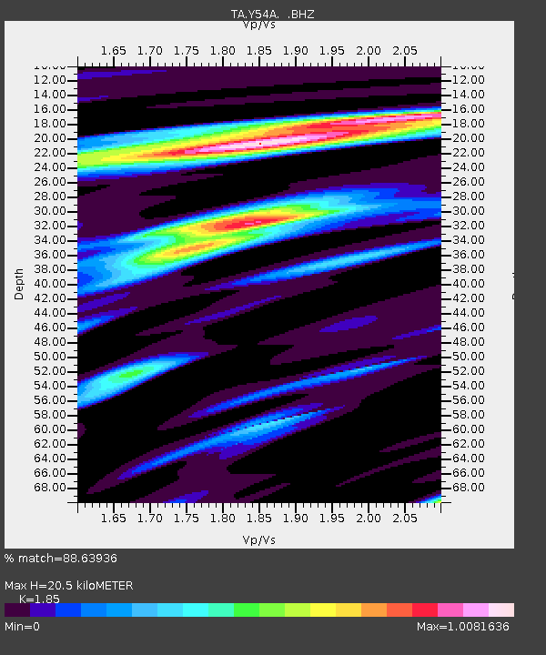
| Estimated Moho Depth: |
20.5 km |
| Estimated Crust Vp/Vs: |
1.85 |
| Assumed Crust Vp: |
6.565 km/s |
| Estimated Crust Vs: |
3.548 km/s |
| Estimated Crust Poisson's Ratio: |
0.29 |
|
| Radial Match: |
88.63936 % |
| Radial Bump: |
295 |
| Transverse Match: |
56.895527 % |
| Transverse Bump: |
400 |
| SOD ConfigId: |
494114 |
| Insert Time: |
2013-05-01 09:51:25.853 +0000 |
| GWidth: |
2.5 |
| Max Bumps: |
400 |
| Tol: |
0.001 |
|
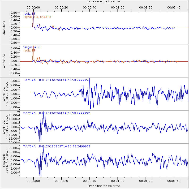
Signal To Noise
| Channel | StoN | STA | LTA |
| TA:Y54A: :BHZ:20130209T14:21:58.249995Z | 10.522273 | 5.59244E-6 | 5.314859E-7 |
| TA:Y54A: :BHN:20130209T14:21:58.249995Z | 7.6657205 | 3.398485E-6 | 4.4333538E-7 |
| TA:Y54A: :BHE:20130209T14:21:58.249995Z | 1.3700473 | 5.872419E-7 | 4.2862894E-7 |
| Arrivals |
| Ps | 2.9 SECOND |
| PpPs | 8.2 SECOND |
| PsPs/PpSs | 11 SECOND |


