You are here: Home > Network List > TA - USArray Transportable Network (new EarthScope stations) Stations List
> Station W53A Cullowhee, NC, USA > Earthquake Result Viewer
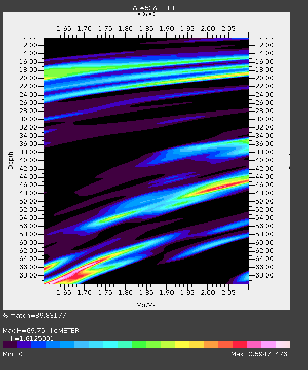
W53A Cullowhee, NC, USA - Earthquake Result Viewer
| Earthquake location: |
Colombia |
| Earthquake latitude/longitude: |
1.1/-77.4 |
| Earthquake time(UTC): |
2013/02/09 (040) 14:16:07 GMT |
| Earthquake Depth: |
145 km |
| Earthquake Magnitude: |
6.7 MB, 6.9 MW, 6.9 MW |
| Earthquake Catalog/Contributor: |
WHDF/NEIC |
|
| Network: |
TA USArray Transportable Network (new EarthScope stations) |
| Station: |
W53A Cullowhee, NC, USA |
| Lat/Lon: |
35.17 N/83.16 W |
| Elevation: |
1180 m |
|
| Distance: |
34.3 deg |
| Az: |
351.592 deg |
| Baz: |
169.721 deg |
| Ray Param: |
0.07733311 |
| Estimated Moho Depth: |
69.75 km |
| Estimated Crust Vp/Vs: |
1.61 |
| Assumed Crust Vp: |
6.35 km/s |
| Estimated Crust Vs: |
3.938 km/s |
| Estimated Crust Poisson's Ratio: |
0.19 |
|
| Radial Match: |
89.83177 % |
| Radial Bump: |
338 |
| Transverse Match: |
71.041214 % |
| Transverse Bump: |
389 |
| SOD ConfigId: |
494114 |
| Insert Time: |
2013-05-01 09:51:48.179 +0000 |
| GWidth: |
2.5 |
| Max Bumps: |
400 |
| Tol: |
0.001 |
|

Signal To Noise
| Channel | StoN | STA | LTA |
| TA:W53A: :BHZ:20130209T14:22:09.925013Z | 4.060378 | 5.527786E-6 | 1.3613969E-6 |
| TA:W53A: :BHN:20130209T14:22:09.925013Z | 9.515607 | 3.605307E-6 | 3.7888356E-7 |
| TA:W53A: :BHE:20130209T14:22:09.925013Z | 0.958672 | 3.215992E-7 | 3.3546323E-7 |
| Arrivals |
| Ps | 7.3 SECOND |
| PpPs | 26 SECOND |
| PsPs/PpSs | 34 SECOND |


