You are here: Home > Network List > TA - USArray Transportable Network (new EarthScope stations) Stations List
> Station W52A Murphy, NC, USA > Earthquake Result Viewer
W52A Murphy, NC, USA - Earthquake Result Viewer
| Earthquake location: |
Colombia |
| Earthquake latitude/longitude: |
1.1/-77.4 |
| Earthquake time(UTC): |
2013/02/09 (040) 14:16:07 GMT |
| Earthquake Depth: |
145 km |
| Earthquake Magnitude: |
6.7 MB, 6.9 MW, 6.9 MW |
| Earthquake Catalog/Contributor: |
WHDF/NEIC |
|
| Network: |
TA USArray Transportable Network (new EarthScope stations) |
| Station: |
W52A Murphy, NC, USA |
| Lat/Lon: |
35.09 N/83.93 W |
| Elevation: |
519 m |
|
| Distance: |
34.3 deg |
| Az: |
350.475 deg |
| Baz: |
168.36 deg |
| Ray Param: |
0.07731027 |
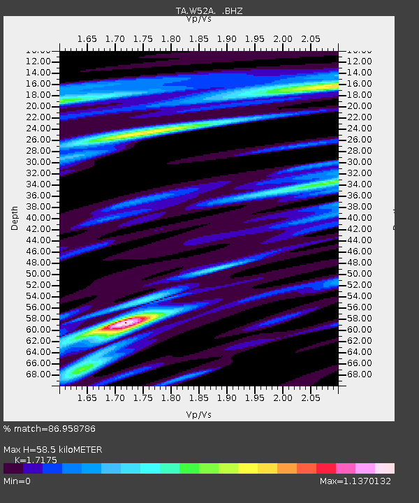
| Estimated Moho Depth: |
58.5 km |
| Estimated Crust Vp/Vs: |
1.72 |
| Assumed Crust Vp: |
6.35 km/s |
| Estimated Crust Vs: |
3.697 km/s |
| Estimated Crust Poisson's Ratio: |
0.24 |
|
| Radial Match: |
86.958786 % |
| Radial Bump: |
400 |
| Transverse Match: |
69.39724 % |
| Transverse Bump: |
400 |
| SOD ConfigId: |
494114 |
| Insert Time: |
2013-05-01 09:51:54.838 +0000 |
| GWidth: |
2.5 |
| Max Bumps: |
400 |
| Tol: |
0.001 |
|
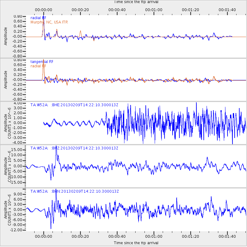
Signal To Noise
| Channel | StoN | STA | LTA |
| TA:W52A: :BHZ:20130209T14:22:10.300013Z | 3.9606504 | 4.1414637E-6 | 1.0456524E-6 |
| TA:W52A: :BHN:20130209T14:22:10.300013Z | 4.5497417 | 3.3444408E-6 | 7.350837E-7 |
| TA:W52A: :BHE:20130209T14:22:10.300013Z | 2.2401793 | 7.3154445E-7 | 3.265562E-7 |
| Arrivals |
| Ps | 7.1 SECOND |
| PpPs | 23 SECOND |
| PsPs/PpSs | 30 SECOND |


