You are here: Home > Network List > TA - USArray Transportable Network (new EarthScope stations) Stations List
> Station T52A Hallie, KY, USA > Earthquake Result Viewer
T52A Hallie, KY, USA - Earthquake Result Viewer
| Earthquake location: |
Colombia |
| Earthquake latitude/longitude: |
1.1/-77.4 |
| Earthquake time(UTC): |
2013/02/09 (040) 14:16:07 GMT |
| Earthquake Depth: |
145 km |
| Earthquake Magnitude: |
6.7 MB, 6.9 MW, 6.9 MW |
| Earthquake Catalog/Contributor: |
WHDF/NEIC |
|
| Network: |
TA USArray Transportable Network (new EarthScope stations) |
| Station: |
T52A Hallie, KY, USA |
| Lat/Lon: |
37.11 N/82.99 W |
| Elevation: |
436 m |
|
| Distance: |
36.2 deg |
| Az: |
352.414 deg |
| Baz: |
170.497 deg |
| Ray Param: |
0.076325886 |
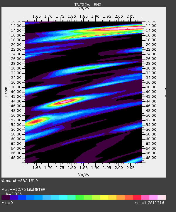
| Estimated Moho Depth: |
12.75 km |
| Estimated Crust Vp/Vs: |
2.04 |
| Assumed Crust Vp: |
6.476 km/s |
| Estimated Crust Vs: |
3.182 km/s |
| Estimated Crust Poisson's Ratio: |
0.34 |
|
| Radial Match: |
85.11819 % |
| Radial Bump: |
400 |
| Transverse Match: |
66.489075 % |
| Transverse Bump: |
400 |
| SOD ConfigId: |
494114 |
| Insert Time: |
2013-05-01 09:52:19.001 +0000 |
| GWidth: |
2.5 |
| Max Bumps: |
400 |
| Tol: |
0.001 |
|
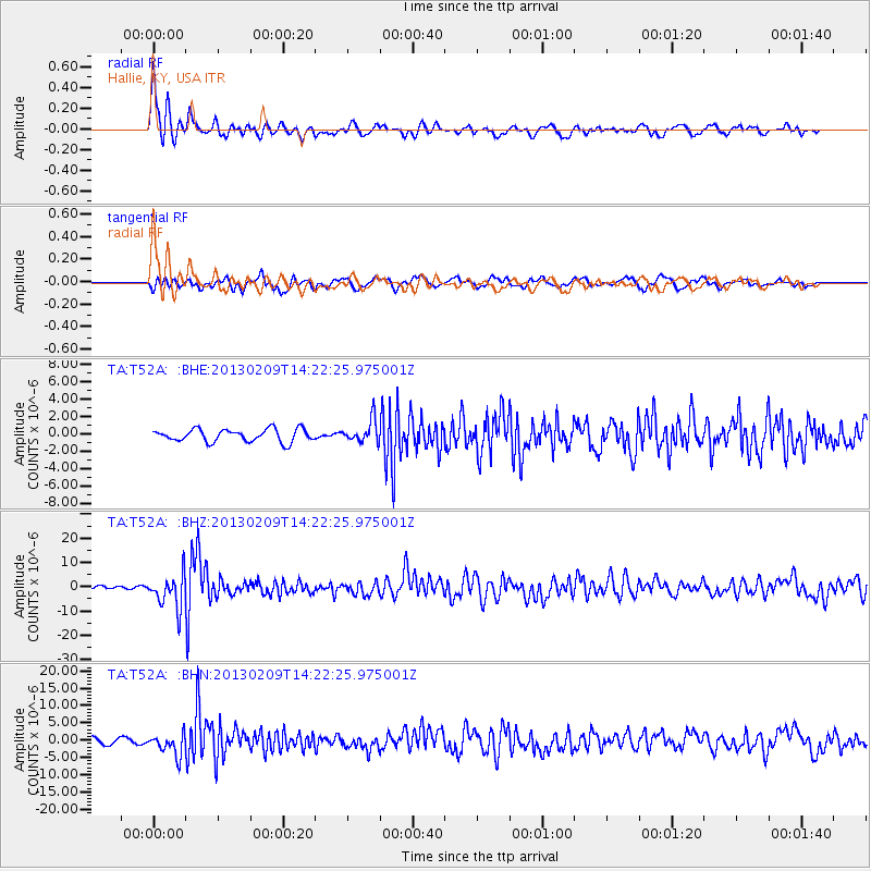
Signal To Noise
| Channel | StoN | STA | LTA |
| TA:T52A: :BHZ:20130209T14:22:25.975001Z | 9.172995 | 6.978228E-6 | 7.607361E-7 |
| TA:T52A: :BHN:20130209T14:22:25.975001Z | 3.4878023 | 3.1390055E-6 | 8.9999526E-7 |
| TA:T52A: :BHE:20130209T14:22:25.975001Z | 1.7841835 | 1.2934906E-6 | 7.2497625E-7 |
| Arrivals |
| Ps | 2.2 SECOND |
| PpPs | 5.6 SECOND |
| PsPs/PpSs | 7.8 SECOND |


