You are here: Home > Network List > TA - USArray Transportable Network (new EarthScope stations) Stations List
> Station Q48A North Vernon, IN, USA > Earthquake Result Viewer
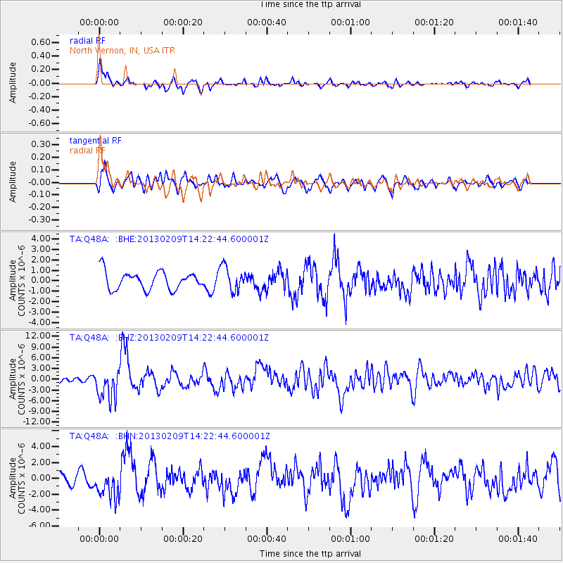
Q48A North Vernon, IN, USA - Earthquake Result Viewer
*The percent match for this event was below the threshold and hence no stack was calculated.
| Earthquake location: |
Colombia |
| Earthquake latitude/longitude: |
1.1/-77.4 |
| Earthquake time(UTC): |
2013/02/09 (040) 14:16:07 GMT |
| Earthquake Depth: |
145 km |
| Earthquake Magnitude: |
6.7 MB, 6.9 MW, 6.9 MW |
| Earthquake Catalog/Contributor: |
WHDF/NEIC |
|
| Network: |
TA USArray Transportable Network (new EarthScope stations) |
| Station: |
Q48A North Vernon, IN, USA |
| Lat/Lon: |
38.93 N/85.73 W |
| Elevation: |
185 m |
|
| Distance: |
38.4 deg |
| Az: |
349.504 deg |
| Baz: |
166.496 deg |
| Ray Param: |
$rayparam |
*The percent match for this event was below the threshold and hence was not used in the summary stack. |
|
| Radial Match: |
73.54313 % |
| Radial Bump: |
400 |
| Transverse Match: |
66.261185 % |
| Transverse Bump: |
400 |
| SOD ConfigId: |
494114 |
| Insert Time: |
2013-05-01 09:54:09.853 +0000 |
| GWidth: |
2.5 |
| Max Bumps: |
400 |
| Tol: |
0.001 |
|
Signal To Noise
| Channel | StoN | STA | LTA |
| TA:Q48A: :BHZ:20130209T14:22:44.600001Z | 3.334532 | 4.284466E-6 | 1.2848777E-6 |
| TA:Q48A: :BHN:20130209T14:22:44.600001Z | 1.5056195 | 1.8104793E-6 | 1.2024813E-6 |
| TA:Q48A: :BHE:20130209T14:22:44.600001Z | 1.3645205 | 1.1623912E-6 | 8.5186775E-7 |
| Arrivals |
| Ps | |
| PpPs | |
| PsPs/PpSs | |


