You are here: Home > Network List > TA - USArray Transportable Network (new EarthScope stations) Stations List
> Station L48A N Adams, MI, USA > Earthquake Result Viewer
L48A N Adams, MI, USA - Earthquake Result Viewer
*The percent match for this event was below the threshold and hence no stack was calculated.
| Earthquake location: |
Colombia |
| Earthquake latitude/longitude: |
1.1/-77.4 |
| Earthquake time(UTC): |
2013/02/09 (040) 14:16:07 GMT |
| Earthquake Depth: |
145 km |
| Earthquake Magnitude: |
6.7 MB, 6.9 MW, 6.9 MW |
| Earthquake Catalog/Contributor: |
WHDF/NEIC |
|
| Network: |
TA USArray Transportable Network (new EarthScope stations) |
| Station: |
L48A N Adams, MI, USA |
| Lat/Lon: |
41.94 N/84.43 W |
| Elevation: |
369 m |
|
| Distance: |
41.1 deg |
| Az: |
352.008 deg |
| Baz: |
169.261 deg |
| Ray Param: |
$rayparam |
*The percent match for this event was below the threshold and hence was not used in the summary stack. |
|
| Radial Match: |
70.38332 % |
| Radial Bump: |
400 |
| Transverse Match: |
73.414604 % |
| Transverse Bump: |
400 |
| SOD ConfigId: |
494114 |
| Insert Time: |
2013-05-01 09:55:03.030 +0000 |
| GWidth: |
2.5 |
| Max Bumps: |
400 |
| Tol: |
0.001 |
|
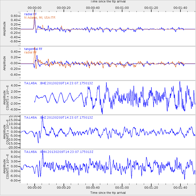
Signal To Noise
| Channel | StoN | STA | LTA |
| TA:L48A: :BHZ:20130209T14:23:07.175013Z | 4.204264 | 5.2518094E-6 | 1.2491626E-6 |
| TA:L48A: :BHN:20130209T14:23:07.175013Z | 2.6393323 | 3.1304319E-6 | 1.1860697E-6 |
| TA:L48A: :BHE:20130209T14:23:07.175013Z | 1.4503219 | 1.3896719E-6 | 9.581817E-7 |
| Arrivals |
| Ps | |
| PpPs | |
| PsPs/PpSs | |


