You are here: Home > Network List > TA - USArray Transportable Network (new EarthScope stations) Stations List
> Station L46A Eue Claire, MI, USA > Earthquake Result Viewer
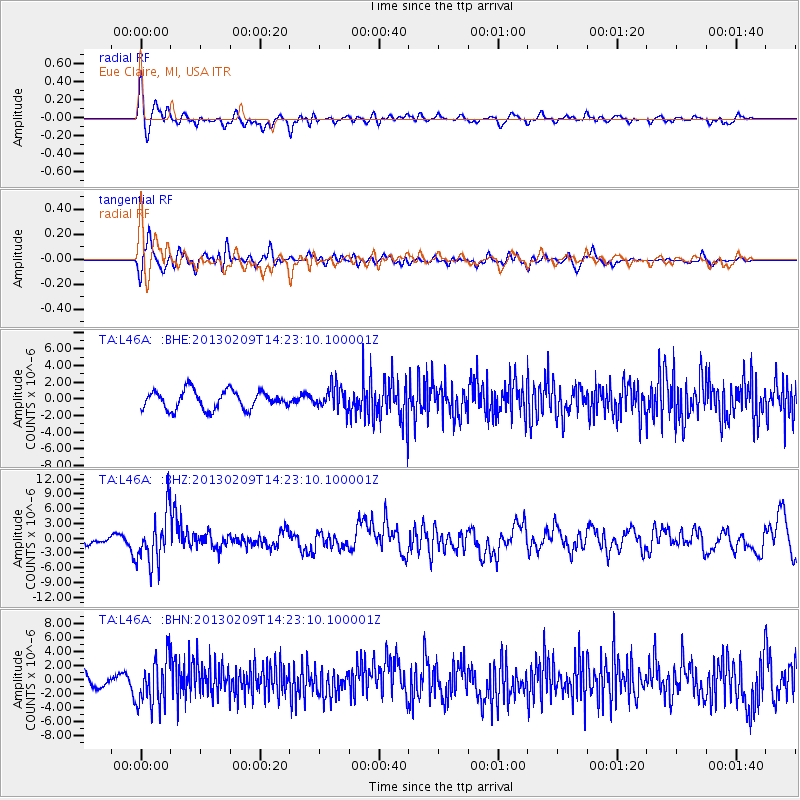
L46A Eue Claire, MI, USA - Earthquake Result Viewer
*The percent match for this event was below the threshold and hence no stack was calculated.
| Earthquake location: |
Colombia |
| Earthquake latitude/longitude: |
1.1/-77.4 |
| Earthquake time(UTC): |
2013/02/09 (040) 14:16:07 GMT |
| Earthquake Depth: |
145 km |
| Earthquake Magnitude: |
6.7 MB, 6.9 MW, 6.9 MW |
| Earthquake Catalog/Contributor: |
WHDF/NEIC |
|
| Network: |
TA USArray Transportable Network (new EarthScope stations) |
| Station: |
L46A Eue Claire, MI, USA |
| Lat/Lon: |
42.01 N/86.30 W |
| Elevation: |
223 m |
|
| Distance: |
41.5 deg |
| Az: |
349.972 deg |
| Baz: |
166.49 deg |
| Ray Param: |
$rayparam |
*The percent match for this event was below the threshold and hence was not used in the summary stack. |
|
| Radial Match: |
53.31513 % |
| Radial Bump: |
400 |
| Transverse Match: |
71.42357 % |
| Transverse Bump: |
400 |
| SOD ConfigId: |
494114 |
| Insert Time: |
2013-05-01 09:56:48.423 +0000 |
| GWidth: |
2.5 |
| Max Bumps: |
400 |
| Tol: |
0.001 |
|
Signal To Noise
| Channel | StoN | STA | LTA |
| TA:L46A: :BHZ:20130209T14:23:10.100001Z | 5.118903 | 5.1723787E-6 | 1.0104466E-6 |
| TA:L46A: :BHN:20130209T14:23:10.100001Z | 2.9553173 | 3.3873082E-6 | 1.1461741E-6 |
| TA:L46A: :BHE:20130209T14:23:10.100001Z | 1.2626765 | 1.3866377E-6 | 1.0981734E-6 |
| Arrivals |
| Ps | |
| PpPs | |
| PsPs/PpSs | |


