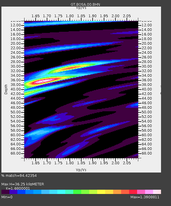
BOSA Boshof, South Africa - Earthquake Result Viewer
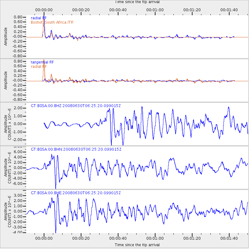
Earthquake location: South Sandwich Islands Region
Earthquake latitude/longitude: -58.2/-22.1
Earthquake time(UTC): 2008/06/30 (182) 06:17:44 GMT
Earthquake Depth: 19 km
Earthquake Magnitude: 6.1 MB, 6.7 MS, 7.0 MW, 6.9 MW
Earthquake Catalog/Contributor: WHDF/NEIC
Network: GT Global Telemetered Seismograph Network (USAF/USGS)
Station: BOSA Boshof, South Africa
Lat/Lon: 28.61 S/25.26 E
Elevation: 1280 m
Distance: 44.0 deg
Az: 68.616 deg
Baz: 214.089 deg
Ray Param: 0.07216904
Estimated Moho Depth: 36.25 km
Estimated Crust Vp/Vs: 1.68
Assumed Crust Vp: 6.459 km/s
Estimated Crust Vs: 3.845 km/s
Estimated Crust Poisson's Ratio: 0.23
Radial Match: 94.42354 %
Radial Bump: 267
Transverse Match: 70.78797 %
Transverse Bump: 400
SOD ConfigId: 2504
Insert Time: 2010-02-27 01:45:53.769 +0000
GWidth: 2.5
Max Bumps: 400
Tol: 0.001

Signal To Noise

ChannelStoNSTALTA
GT:BOSA:00:BHN:20080630T06:25:20.099015Z7.56881052.1360615E-62.8221893E-7
GT:BOSA:00:BHE:20080630T06:25:20.099015Z4.4575541.1564695E-62.5944038E-7
GT:BOSA:00:BHZ:20080630T06:25:20.099015Z4.00851737.5710057E-71.8887297E-7
Arrivals
Ps4.1 SECOND
PpPs14 SECOND
PsPs/PpSs18 SECOND