You are here: Home > Network List > TA - USArray Transportable Network (new EarthScope stations) Stations List
> Station Q54A Coxs Mills, WV, USA > Earthquake Result Viewer
Q54A Coxs Mills, WV, USA - Earthquake Result Viewer
| Earthquake location: |
Colombia |
| Earthquake latitude/longitude: |
1.1/-77.4 |
| Earthquake time(UTC): |
2013/02/09 (040) 14:16:07 GMT |
| Earthquake Depth: |
145 km |
| Earthquake Magnitude: |
6.7 MB, 6.9 MW, 6.9 MW |
| Earthquake Catalog/Contributor: |
WHDF/NEIC |
|
| Network: |
TA USArray Transportable Network (new EarthScope stations) |
| Station: |
Q54A Coxs Mills, WV, USA |
| Lat/Lon: |
38.98 N/80.83 W |
| Elevation: |
254 m |
|
| Distance: |
37.8 deg |
| Az: |
355.623 deg |
| Baz: |
174.382 deg |
| Ray Param: |
0.07540754 |
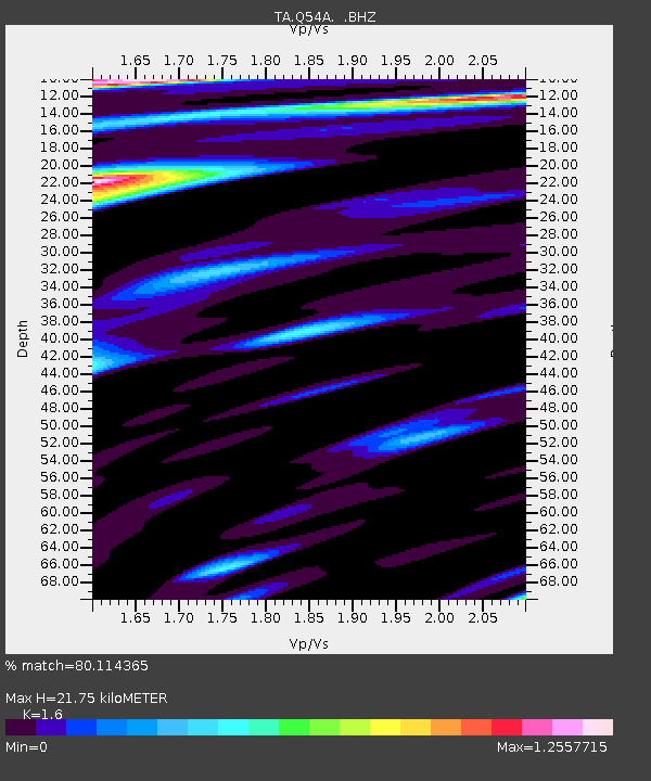
| Estimated Moho Depth: |
21.75 km |
| Estimated Crust Vp/Vs: |
1.60 |
| Assumed Crust Vp: |
6.207 km/s |
| Estimated Crust Vs: |
3.879 km/s |
| Estimated Crust Poisson's Ratio: |
0.18 |
|
| Radial Match: |
80.114365 % |
| Radial Bump: |
400 |
| Transverse Match: |
65.22053 % |
| Transverse Bump: |
400 |
| SOD ConfigId: |
494114 |
| Insert Time: |
2013-05-01 10:02:24.096 +0000 |
| GWidth: |
2.5 |
| Max Bumps: |
400 |
| Tol: |
0.001 |
|

Signal To Noise
| Channel | StoN | STA | LTA |
| TA:Q54A: :BHZ:20130209T14:22:39.749995Z | 5.148765 | 5.8675337E-6 | 1.1396002E-6 |
| TA:Q54A: :BHN:20130209T14:22:39.749995Z | 2.421543 | 2.6370003E-6 | 1.0889753E-6 |
| TA:Q54A: :BHE:20130209T14:22:39.749995Z | 0.45962414 | 5.041107E-7 | 1.096789E-6 |
| Arrivals |
| Ps | 2.3 SECOND |
| PpPs | 8.5 SECOND |
| PsPs/PpSs | 11 SECOND |


