You are here: Home > Network List > TA - USArray Transportable Network (new EarthScope stations) Stations List
> Station I03D Drain, OR, USA > Earthquake Result Viewer
I03D Drain, OR, USA - Earthquake Result Viewer
*The percent match for this event was below the threshold and hence no stack was calculated.
| Earthquake location: |
Santa Cruz Islands |
| Earthquake latitude/longitude: |
-11.0/165.7 |
| Earthquake time(UTC): |
2013/02/09 (040) 21:02:22 GMT |
| Earthquake Depth: |
18 km |
| Earthquake Magnitude: |
6.0 MB, 6.5 MS, 6.6 MW, 6.5 MW |
| Earthquake Catalog/Contributor: |
WHDF/NEIC |
|
| Network: |
TA USArray Transportable Network (new EarthScope stations) |
| Station: |
I03D Drain, OR, USA |
| Lat/Lon: |
43.70 N/123.35 W |
| Elevation: |
140 m |
|
| Distance: |
84.1 deg |
| Az: |
43.555 deg |
| Baz: |
248.876 deg |
| Ray Param: |
$rayparam |
*The percent match for this event was below the threshold and hence was not used in the summary stack. |
|
| Radial Match: |
55.983818 % |
| Radial Bump: |
400 |
| Transverse Match: |
42.072895 % |
| Transverse Bump: |
326 |
| SOD ConfigId: |
494114 |
| Insert Time: |
2013-05-01 10:12:47.021 +0000 |
| GWidth: |
2.5 |
| Max Bumps: |
400 |
| Tol: |
0.001 |
|
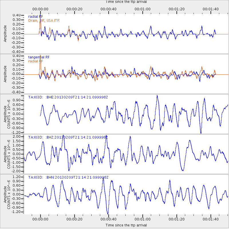
Signal To Noise
| Channel | StoN | STA | LTA |
| TA:I03D: :BHZ:20130209T21:14:21.099998Z | 1.9265847 | 8.742093E-7 | 4.5376115E-7 |
| TA:I03D: :BHN:20130209T21:14:21.099998Z | 0.8485342 | 2.7394E-7 | 3.2283907E-7 |
| TA:I03D: :BHE:20130209T21:14:21.099998Z | 0.8219005 | 2.598329E-7 | 3.161367E-7 |
| Arrivals |
| Ps | |
| PpPs | |
| PsPs/PpSs | |


