You are here: Home > Network List > UW - Pacific Northwest Regional Seismic Network Stations List
> Station OMAK Colville Reservation, Omak, WA, USA > Earthquake Result Viewer
OMAK Colville Reservation, Omak, WA, USA - Earthquake Result Viewer
*The percent match for this event was below the threshold and hence no stack was calculated.
| Earthquake location: |
Santa Cruz Islands |
| Earthquake latitude/longitude: |
-11.0/165.7 |
| Earthquake time(UTC): |
2013/02/09 (040) 21:02:22 GMT |
| Earthquake Depth: |
18 km |
| Earthquake Magnitude: |
6.0 MB, 6.5 MS, 6.6 MW, 6.5 MW |
| Earthquake Catalog/Contributor: |
WHDF/NEIC |
|
| Network: |
UW Pacific Northwest Regional Seismic Network |
| Station: |
OMAK Colville Reservation, Omak, WA, USA |
| Lat/Lon: |
48.36 N/119.33 W |
| Elevation: |
696 m |
|
| Distance: |
88.3 deg |
| Az: |
40.112 deg |
| Baz: |
251.532 deg |
| Ray Param: |
$rayparam |
*The percent match for this event was below the threshold and hence was not used in the summary stack. |
|
| Radial Match: |
71.58505 % |
| Radial Bump: |
400 |
| Transverse Match: |
52.872498 % |
| Transverse Bump: |
380 |
| SOD ConfigId: |
494114 |
| Insert Time: |
2013-05-01 10:13:21.826 +0000 |
| GWidth: |
2.5 |
| Max Bumps: |
400 |
| Tol: |
0.001 |
|
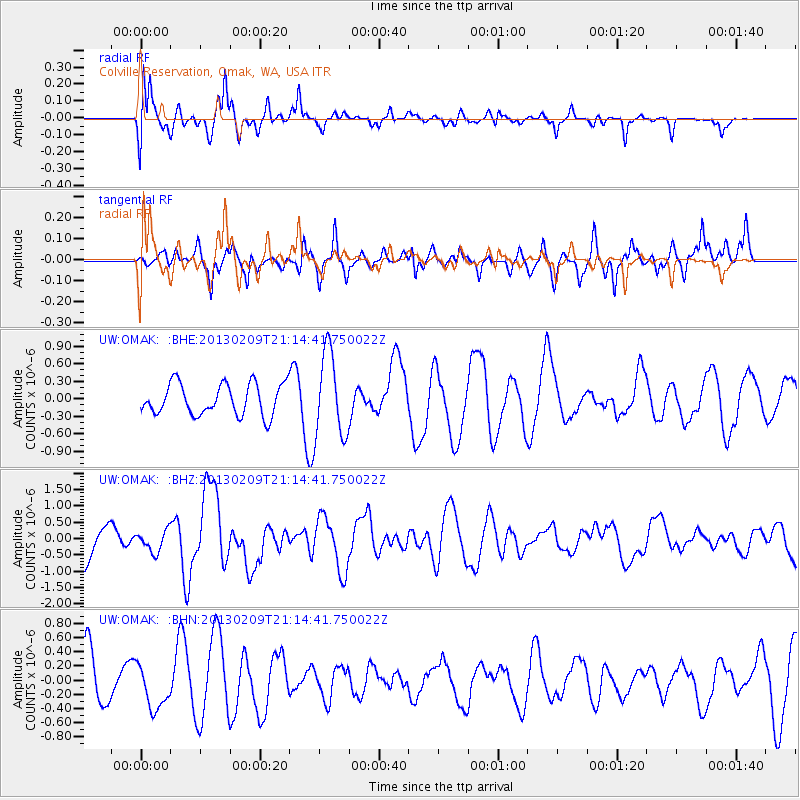
Signal To Noise
| Channel | StoN | STA | LTA |
| UW:OMAK: :BHZ:20130209T21:14:41.750022Z | 0.63509715 | 3.2221436E-7 | 5.0734656E-7 |
| UW:OMAK: :BHN:20130209T21:14:41.750022Z | 0.63728905 | 3.1606112E-7 | 4.9594627E-7 |
| UW:OMAK: :BHE:20130209T21:14:41.750022Z | 2.7086298 | 7.212817E-7 | 2.6629024E-7 |
| Arrivals |
| Ps | |
| PpPs | |
| PsPs/PpSs | |


