You are here: Home > Network List > CI - Caltech Regional Seismic Network Stations List
> Station BAR Barrett, Tecate, CA, USA > Earthquake Result Viewer
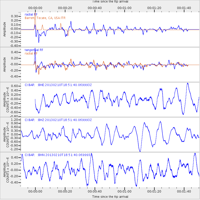
BAR Barrett, Tecate, CA, USA - Earthquake Result Viewer
*The percent match for this event was below the threshold and hence no stack was calculated.
| Earthquake location: |
Santa Cruz Islands |
| Earthquake latitude/longitude: |
-10.9/165.5 |
| Earthquake time(UTC): |
2013/02/10 (041) 18:39:32 GMT |
| Earthquake Depth: |
11 km |
| Earthquake Magnitude: |
5.5 MB, 5.9 MS, 6.0 MW, 5.9 MW |
| Earthquake Catalog/Contributor: |
WHDF/NEIC |
|
| Network: |
CI Caltech Regional Seismic Network |
| Station: |
BAR Barrett, Tecate, CA, USA |
| Lat/Lon: |
32.68 N/116.67 W |
| Elevation: |
521 m |
|
| Distance: |
85.8 deg |
| Az: |
55.76 deg |
| Baz: |
254.297 deg |
| Ray Param: |
$rayparam |
*The percent match for this event was below the threshold and hence was not used in the summary stack. |
|
| Radial Match: |
60.9863 % |
| Radial Bump: |
400 |
| Transverse Match: |
54.061604 % |
| Transverse Bump: |
400 |
| SOD ConfigId: |
494114 |
| Insert Time: |
2013-05-01 10:23:21.630 +0000 |
| GWidth: |
2.5 |
| Max Bumps: |
400 |
| Tol: |
0.001 |
|
Signal To Noise
| Channel | StoN | STA | LTA |
| CI:BAR: :BHZ:20130210T18:51:40.069993Z | 1.0745631 | 2.5074814E-7 | 2.3334893E-7 |
| CI:BAR: :BHN:20130210T18:51:40.069993Z | 0.5525528 | 1.5428809E-7 | 2.7922775E-7 |
| CI:BAR: :BHE:20130210T18:51:40.069993Z | 0.67382896 | 1.5963484E-7 | 2.3690706E-7 |
| Arrivals |
| Ps | |
| PpPs | |
| PsPs/PpSs | |


