You are here: Home > Network List > TA - USArray Transportable Network (new EarthScope stations) Stations List
> Station J05D Fort Rock, OR, USA > Earthquake Result Viewer
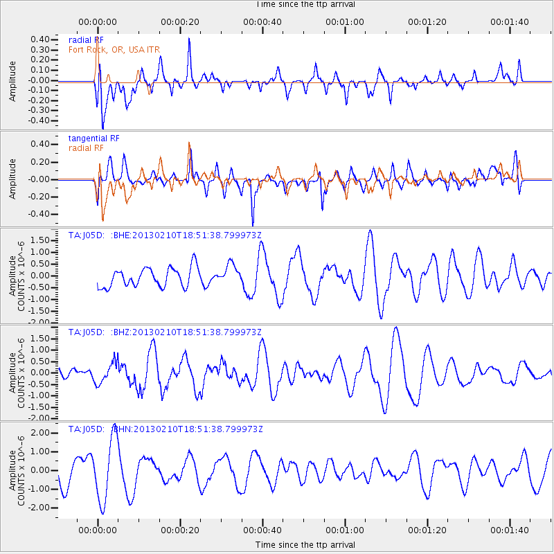
J05D Fort Rock, OR, USA - Earthquake Result Viewer
*The percent match for this event was below the threshold and hence no stack was calculated.
| Earthquake location: |
Santa Cruz Islands |
| Earthquake latitude/longitude: |
-10.9/165.5 |
| Earthquake time(UTC): |
2013/02/10 (041) 18:39:32 GMT |
| Earthquake Depth: |
11 km |
| Earthquake Magnitude: |
5.5 MB, 5.9 MS, 6.0 MW, 5.9 MW |
| Earthquake Catalog/Contributor: |
WHDF/NEIC |
|
| Network: |
TA USArray Transportable Network (new EarthScope stations) |
| Station: |
J05D Fort Rock, OR, USA |
| Lat/Lon: |
43.28 N/121.23 W |
| Elevation: |
1541 m |
|
| Distance: |
85.6 deg |
| Az: |
44.552 deg |
| Baz: |
250.644 deg |
| Ray Param: |
$rayparam |
*The percent match for this event was below the threshold and hence was not used in the summary stack. |
|
| Radial Match: |
52.8753 % |
| Radial Bump: |
400 |
| Transverse Match: |
41.540737 % |
| Transverse Bump: |
400 |
| SOD ConfigId: |
494114 |
| Insert Time: |
2013-05-01 10:25:40.481 +0000 |
| GWidth: |
2.5 |
| Max Bumps: |
400 |
| Tol: |
0.001 |
|
Signal To Noise
| Channel | StoN | STA | LTA |
| TA:J05D: :BHZ:20130210T18:51:38.799973Z | 1.0094547 | 4.5936096E-7 | 4.5505848E-7 |
| TA:J05D: :BHN:20130210T18:51:38.799973Z | 2.6458828 | 1.7082883E-6 | 6.4564017E-7 |
| TA:J05D: :BHE:20130210T18:51:38.799973Z | 1.0690414 | 4.2834876E-7 | 4.006849E-7 |
| Arrivals |
| Ps | |
| PpPs | |
| PsPs/PpSs | |


