You are here: Home > Network List > AZ - ANZA Regional Network Stations List
> Station LVA2 AZ.LVA2 > Earthquake Result Viewer
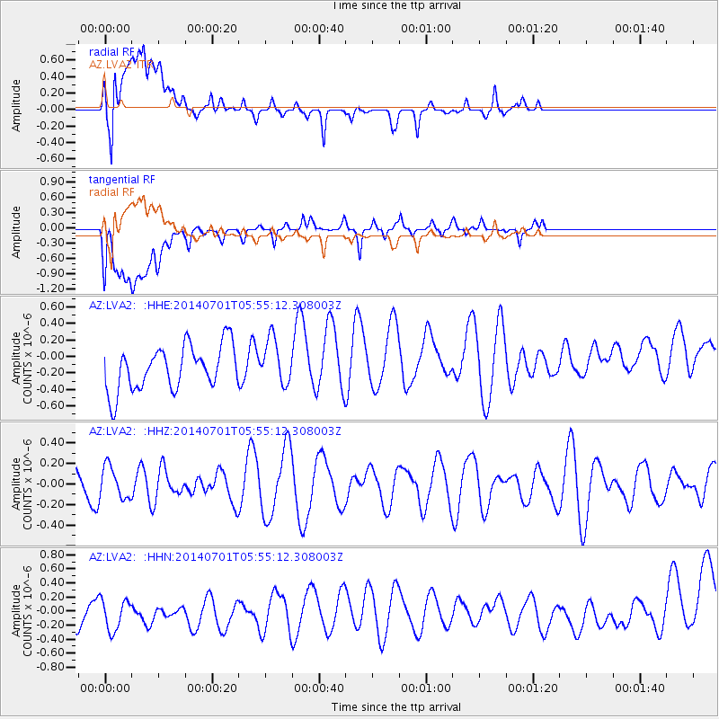
LVA2 AZ.LVA2 - Earthquake Result Viewer
*The percent match for this event was below the threshold and hence no stack was calculated.
| Earthquake location: |
Pacific-Antarctic Ridge |
| Earthquake latitude/longitude: |
-56.6/-141.8 |
| Earthquake time(UTC): |
2014/07/01 (182) 05:42:34 GMT |
| Earthquake Depth: |
10 km |
| Earthquake Magnitude: |
5.6 MW |
| Earthquake Catalog/Contributor: |
ISC/ISC |
|
| Network: |
AZ ANZA Regional Network |
| Station: |
LVA2 AZ.LVA2 |
| Lat/Lon: |
33.35 N/116.56 W |
| Elevation: |
1435 m |
|
| Distance: |
92.2 deg |
| Az: |
20.931 deg |
| Baz: |
193.636 deg |
| Ray Param: |
$rayparam |
*The percent match for this event was below the threshold and hence was not used in the summary stack. |
|
| Radial Match: |
55.70288 % |
| Radial Bump: |
400 |
| Transverse Match: |
37.401104 % |
| Transverse Bump: |
400 |
| SOD ConfigId: |
3390531 |
| Insert Time: |
2019-04-12 15:30:49.125 +0000 |
| GWidth: |
2.5 |
| Max Bumps: |
400 |
| Tol: |
0.001 |
|
Signal To Noise
| Channel | StoN | STA | LTA |
| AZ:LVA2: :HHZ:20140701T05:55:12.308003Z | 0.85127187 | 1.5455747E-7 | 1.8156064E-7 |
| AZ:LVA2: :HHN:20140701T05:55:12.308003Z | 1.6047527 | 3.0844814E-7 | 1.9220914E-7 |
| AZ:LVA2: :HHE:20140701T05:55:12.308003Z | 1.0352206 | 2.782978E-7 | 2.6882944E-7 |
| Arrivals |
| Ps | |
| PpPs | |
| PsPs/PpSs | |


