You are here: Home > Network List > IC - New China Digital Seismograph Network Stations List
> Station LSA Tibet, China > Earthquake Result Viewer
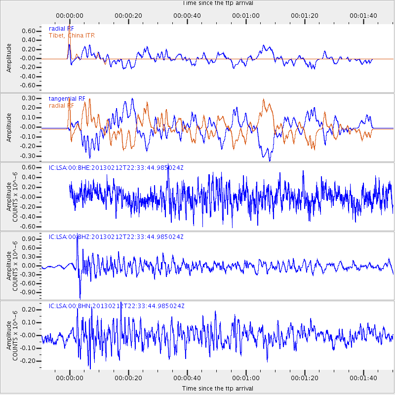
LSA Tibet, China - Earthquake Result Viewer
*The percent match for this event was below the threshold and hence no stack was calculated.
| Earthquake location: |
Tanimbar Islands Reg., Indonesia |
| Earthquake latitude/longitude: |
-6.9/131.4 |
| Earthquake time(UTC): |
2013/02/12 (043) 22:25:03 GMT |
| Earthquake Depth: |
54 km |
| Earthquake Magnitude: |
5.6 MB, 5.3 MW |
| Earthquake Catalog/Contributor: |
WHDF/NEIC |
|
| Network: |
IC New China Digital Seismograph Network |
| Station: |
LSA Tibet, China |
| Lat/Lon: |
29.70 N/91.13 E |
| Elevation: |
3660 m |
|
| Distance: |
53.1 deg |
| Az: |
315.353 deg |
| Baz: |
126.685 deg |
| Ray Param: |
$rayparam |
*The percent match for this event was below the threshold and hence was not used in the summary stack. |
|
| Radial Match: |
54.131496 % |
| Radial Bump: |
400 |
| Transverse Match: |
46.0432 % |
| Transverse Bump: |
400 |
| SOD ConfigId: |
494114 |
| Insert Time: |
2013-05-04 05:13:40.916 +0000 |
| GWidth: |
2.5 |
| Max Bumps: |
400 |
| Tol: |
0.001 |
|
Signal To Noise
| Channel | StoN | STA | LTA |
| IC:LSA:00:BHZ:20130212T22:33:44.985024Z | 7.4403057 | 3.7386047E-7 | 5.0248E-8 |
| IC:LSA:00:BHN:20130212T22:33:44.985024Z | 2.4074254 | 7.7448966E-8 | 3.217087E-8 |
| IC:LSA:00:BHE:20130212T22:33:44.985024Z | 1.5141394 | 2.2980804E-7 | 1.5177469E-7 |
| Arrivals |
| Ps | |
| PpPs | |
| PsPs/PpSs | |


