You are here: Home > Network List > PS - Pacific21 Stations List
> Station PATS 6onpei, Micronesia > Earthquake Result Viewer
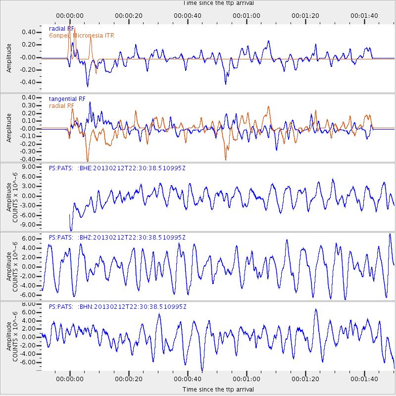
PATS 6onpei, Micronesia - Earthquake Result Viewer
*The percent match for this event was below the threshold and hence no stack was calculated.
| Earthquake location: |
Tanimbar Islands Reg., Indonesia |
| Earthquake latitude/longitude: |
-6.9/131.4 |
| Earthquake time(UTC): |
2013/02/12 (043) 22:25:03 GMT |
| Earthquake Depth: |
54 km |
| Earthquake Magnitude: |
5.6 MB, 5.3 MW |
| Earthquake Catalog/Contributor: |
WHDF/NEIC |
|
| Network: |
PS Pacific21 |
| Station: |
PATS 6onpei, Micronesia |
| Lat/Lon: |
6.84 N/158.32 E |
| Elevation: |
10 m |
|
| Distance: |
30.2 deg |
| Az: |
63.642 deg |
| Baz: |
243.625 deg |
| Ray Param: |
$rayparam |
*The percent match for this event was below the threshold and hence was not used in the summary stack. |
|
| Radial Match: |
22.58485 % |
| Radial Bump: |
400 |
| Transverse Match: |
37.890793 % |
| Transverse Bump: |
400 |
| SOD ConfigId: |
494114 |
| Insert Time: |
2013-05-04 05:14:54.301 +0000 |
| GWidth: |
2.5 |
| Max Bumps: |
400 |
| Tol: |
0.001 |
|
Signal To Noise
| Channel | StoN | STA | LTA |
| PS:PATS: :BHZ:20130212T22:30:38.510995Z | 1.365665 | 3.778712E-6 | 2.7669394E-6 |
| PS:PATS: :BHN:20130212T22:30:38.510995Z | 1.3443371 | 3.9507054E-6 | 2.9387759E-6 |
| PS:PATS: :BHE:20130212T22:30:38.510995Z | 1.1712831 | 3.4087245E-6 | 2.910248E-6 |
| Arrivals |
| Ps | |
| PpPs | |
| PsPs/PpSs | |


