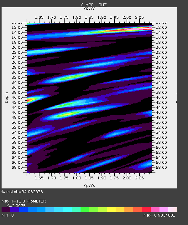
MPP McPhearson Peak - Earthquake Result Viewer
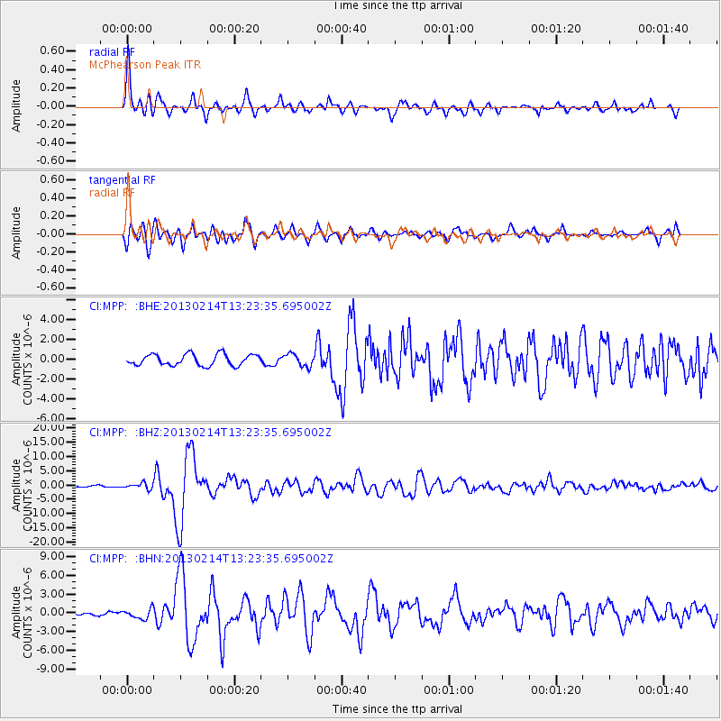
Earthquake location: Eastern Siberia, Russia
Earthquake latitude/longitude: 67.6/142.5
Earthquake time(UTC): 2013/02/14 (045) 13:13:53 GMT
Earthquake Depth: 11 km
Earthquake Magnitude: 6.5 MB, 6.7 MS, 6.6 MW, 6.7 MW
Earthquake Catalog/Contributor: WHDF/NEIC
Network: CI Caltech Regional Seismic Network
Station: MPP McPhearson Peak
Lat/Lon: 34.89 N/119.81 W
Elevation: 1739 m
Distance: 61.1 deg
Az: 68.591 deg
Baz: 334.311 deg
Ray Param: 0.061123256
Estimated Moho Depth: 12.0 km
Estimated Crust Vp/Vs: 2.10
Assumed Crust Vp: 6.1 km/s
Estimated Crust Vs: 2.908 km/s
Estimated Crust Poisson's Ratio: 0.35
Radial Match: 94.052376 %
Radial Bump: 400
Transverse Match: 83.39188 %
Transverse Bump: 400
SOD ConfigId: 494114
Insert Time: 2013-05-04 05:37:52.896 +0000
GWidth: 2.5
Max Bumps: 400
Tol: 0.001

Signal To Noise

ChannelStoNSTALTA
CI:MPP: :BHZ:20130214T13:23:35.695002Z3.33866791.0009841E-62.998154E-7
CI:MPP: :BHN:20130214T13:23:35.695002Z1.51802187.889158E-75.1969994E-7
CI:MPP: :BHE:20130214T13:23:35.695002Z1.1270546.393E-75.6723104E-7
Arrivals
Ps2.2 SECOND
PpPs5.9 SECOND
PsPs/PpSs8.1 SECOND