You are here: Home > Network List > CI - Caltech Regional Seismic Network Stations List
> Station BEL Belle Mtn, Joshua Tree National Park, CA, USA > Earthquake Result Viewer
BEL Belle Mtn, Joshua Tree National Park, CA, USA - Earthquake Result Viewer
| Earthquake location: |
Eastern Siberia, Russia |
| Earthquake latitude/longitude: |
67.6/142.5 |
| Earthquake time(UTC): |
2013/02/14 (045) 13:13:53 GMT |
| Earthquake Depth: |
11 km |
| Earthquake Magnitude: |
6.5 MB, 6.7 MS, 6.6 MW, 6.7 MW |
| Earthquake Catalog/Contributor: |
WHDF/NEIC |
|
| Network: |
CI Caltech Regional Seismic Network |
| Station: |
BEL Belle Mtn, Joshua Tree National Park, CA, USA |
| Lat/Lon: |
34.00 N/116.00 W |
| Elevation: |
1388 m |
|
| Distance: |
63.2 deg |
| Az: |
65.793 deg |
| Baz: |
335.151 deg |
| Ray Param: |
0.05972866 |
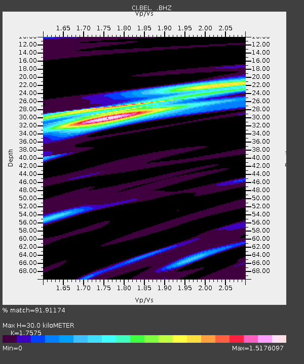
| Estimated Moho Depth: |
30.0 km |
| Estimated Crust Vp/Vs: |
1.76 |
| Assumed Crust Vp: |
6.276 km/s |
| Estimated Crust Vs: |
3.571 km/s |
| Estimated Crust Poisson's Ratio: |
0.26 |
|
| Radial Match: |
91.91174 % |
| Radial Bump: |
400 |
| Transverse Match: |
76.03355 % |
| Transverse Bump: |
400 |
| SOD ConfigId: |
494114 |
| Insert Time: |
2013-05-04 05:38:06.033 +0000 |
| GWidth: |
2.5 |
| Max Bumps: |
400 |
| Tol: |
0.001 |
|
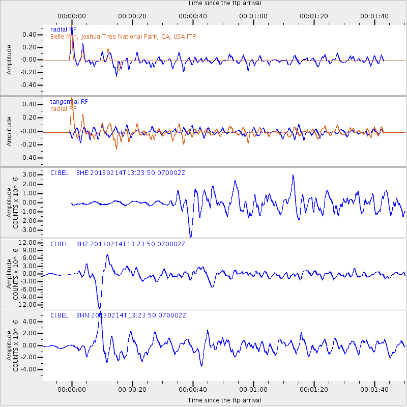
Signal To Noise
| Channel | StoN | STA | LTA |
| CI:BEL: :BHZ:20130214T13:23:50.070002Z | 4.581694 | 1.17302E-6 | 2.560232E-7 |
| CI:BEL: :BHN:20130214T13:23:50.070002Z | 2.6931028 | 4.4175334E-7 | 1.6403138E-7 |
| CI:BEL: :BHE:20130214T13:23:50.070002Z | 1.9008735 | 2.5388013E-7 | 1.3355971E-7 |
| Arrivals |
| Ps | 3.8 SECOND |
| PpPs | 13 SECOND |
| PsPs/PpSs | 16 SECOND |


