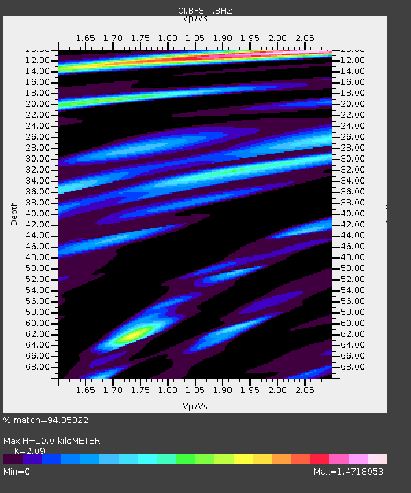
BFS Mt Baldy Forest Station - Earthquake Result Viewer
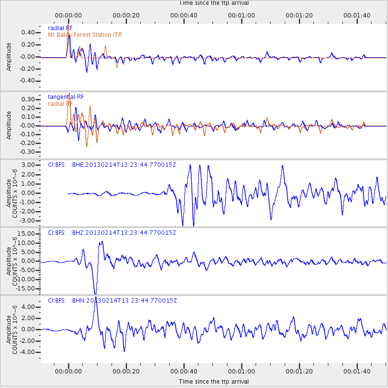
Earthquake location: Eastern Siberia, Russia
Earthquake latitude/longitude: 67.6/142.5
Earthquake time(UTC): 2013/02/14 (045) 13:13:53 GMT
Earthquake Depth: 11 km
Earthquake Magnitude: 6.5 MB, 6.7 MS, 6.6 MW, 6.7 MW
Earthquake Catalog/Contributor: WHDF/NEIC
Network: CI Caltech Regional Seismic Network
Station: BFS Mt Baldy Forest Station
Lat/Lon: 34.24 N/117.66 W
Elevation: 1312 m
Distance: 62.4 deg
Az: 67.084 deg
Baz: 334.814 deg
Ray Param: 0.0602474
Estimated Moho Depth: 10.0 km
Estimated Crust Vp/Vs: 2.09
Assumed Crust Vp: 6.276 km/s
Estimated Crust Vs: 3.003 km/s
Estimated Crust Poisson's Ratio: 0.35
Radial Match: 94.85822 %
Radial Bump: 400
Transverse Match: 94.21395 %
Transverse Bump: 400
SOD ConfigId: 494114
Insert Time: 2013-05-04 05:38:17.988 +0000
GWidth: 2.5
Max Bumps: 400
Tol: 0.001

Signal To Noise

ChannelStoNSTALTA
CI:BFS: :BHZ:20130214T13:23:44.770015Z6.3239631.2532212E-61.9817023E-7
CI:BFS: :BHN:20130214T13:23:44.770015Z3.00338483.5871759E-71.1943777E-7
CI:BFS: :BHE:20130214T13:23:44.770015Z2.4496812.4759984E-71.0107432E-7
Arrivals
Ps1.8 SECOND
PpPs4.8 SECOND
PsPs/PpSs6.6 SECOND