You are here: Home > Network List > GT - Global Telemetered Seismograph Network (USAF/USGS) Stations List
> Station BOSA Boshof, South Africa > Earthquake Result Viewer
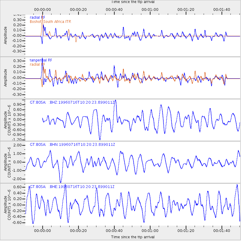
BOSA Boshof, South Africa - Earthquake Result Viewer
*The percent match for this event was below the threshold and hence no stack was calculated.
| Earthquake location: |
Minahassa Peninsula, Sulawesi |
| Earthquake latitude/longitude: |
1.0/120.3 |
| Earthquake time(UTC): |
1996/07/16 (198) 10:07:36 GMT |
| Earthquake Depth: |
33 km |
| Earthquake Magnitude: |
6.0 MB, 6.4 MS, 6.6 UNKNOWN, 6.6 MW |
| Earthquake Catalog/Contributor: |
WHDF/NEIC |
|
| Network: |
GT Global Telemetered Seismograph Network (USAF/USGS) |
| Station: |
BOSA Boshof, South Africa |
| Lat/Lon: |
28.61 S/25.26 E |
| Elevation: |
1280 m |
|
| Distance: |
94.9 deg |
| Az: |
241.528 deg |
| Baz: |
91.496 deg |
| Ray Param: |
$rayparam |
*The percent match for this event was below the threshold and hence was not used in the summary stack. |
|
| Radial Match: |
65.504005 % |
| Radial Bump: |
400 |
| Transverse Match: |
57.366486 % |
| Transverse Bump: |
400 |
| SOD ConfigId: |
4480 |
| Insert Time: |
2010-02-27 01:47:27.584 +0000 |
| GWidth: |
2.5 |
| Max Bumps: |
400 |
| Tol: |
0.001 |
|
Signal To Noise
| Channel | StoN | STA | LTA |
| GT:BOSA: :BHN:19960716T10:20:23.899011Z | 1.3108978 | 6.843261E-7 | 5.2202853E-7 |
| GT:BOSA: :BHE:19960716T10:20:23.899011Z | 0.59192896 | 2.0526141E-7 | 3.46767E-7 |
| GT:BOSA: :BHZ:19960716T10:20:23.899011Z | 3.0815785 | 6.0480556E-7 | 1.9626486E-7 |
| Arrivals |
| Ps | |
| PpPs | |
| PsPs/PpSs | |


