You are here: Home > Network List > TA - USArray Transportable Network (new EarthScope stations) Stations List
> Station T25A Trinidad, CO, USA > Earthquake Result Viewer
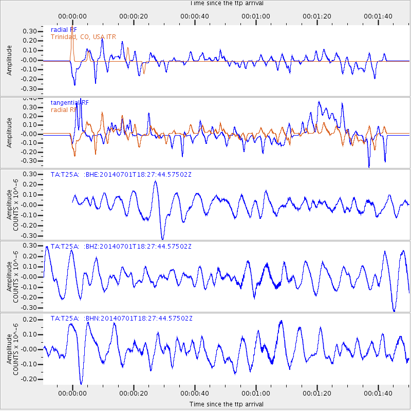
T25A Trinidad, CO, USA - Earthquake Result Viewer
*The percent match for this event was below the threshold and hence no stack was calculated.
| Earthquake location: |
Kermadec Islands, New Zealand |
| Earthquake latitude/longitude: |
-30.4/-177.1 |
| Earthquake time(UTC): |
2014/07/01 (182) 18:14:53 GMT |
| Earthquake Depth: |
24 km |
| Earthquake Magnitude: |
5.0 MW |
| Earthquake Catalog/Contributor: |
ISC/ISC |
|
| Network: |
TA USArray Transportable Network (new EarthScope stations) |
| Station: |
T25A Trinidad, CO, USA |
| Lat/Lon: |
37.14 N/104.41 W |
| Elevation: |
2017 m |
|
| Distance: |
95.6 deg |
| Az: |
50.035 deg |
| Baz: |
235.982 deg |
| Ray Param: |
$rayparam |
*The percent match for this event was below the threshold and hence was not used in the summary stack. |
|
| Radial Match: |
62.901398 % |
| Radial Bump: |
400 |
| Transverse Match: |
66.62588 % |
| Transverse Bump: |
400 |
| SOD ConfigId: |
3390531 |
| Insert Time: |
2019-04-12 15:44:16.732 +0000 |
| GWidth: |
2.5 |
| Max Bumps: |
400 |
| Tol: |
0.001 |
|
Signal To Noise
| Channel | StoN | STA | LTA |
| TA:T25A: :BHZ:20140701T18:27:44.57502Z | 1.162166 | 1.4941708E-7 | 1.2856775E-7 |
| TA:T25A: :BHN:20140701T18:27:44.57502Z | 2.0389516 | 1.5775473E-7 | 7.737051E-8 |
| TA:T25A: :BHE:20140701T18:27:44.57502Z | 2.394006 | 1.7367644E-7 | 7.254637E-8 |
| Arrivals |
| Ps | |
| PpPs | |
| PsPs/PpSs | |


