You are here: Home > Network List > TA - USArray Transportable Network (new EarthScope stations) Stations List
> Station Y43A Makayla and Karen, Gunnison, MS, USA > Earthquake Result Viewer
Y43A Makayla and Karen, Gunnison, MS, USA - Earthquake Result Viewer
| Earthquake location: |
Eastern Siberia, Russia |
| Earthquake latitude/longitude: |
67.6/142.5 |
| Earthquake time(UTC): |
2013/02/14 (045) 13:13:53 GMT |
| Earthquake Depth: |
11 km |
| Earthquake Magnitude: |
6.5 MB, 6.7 MS, 6.6 MW, 6.7 MW |
| Earthquake Catalog/Contributor: |
WHDF/NEIC |
|
| Network: |
TA USArray Transportable Network (new EarthScope stations) |
| Station: |
Y43A Makayla and Karen, Gunnison, MS, USA |
| Lat/Lon: |
33.91 N/90.93 W |
| Elevation: |
46 m |
|
| Distance: |
71.1 deg |
| Az: |
44.902 deg |
| Baz: |
341.041 deg |
| Ray Param: |
0.054522324 |
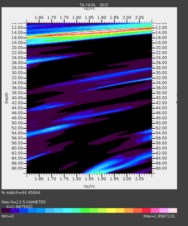
| Estimated Moho Depth: |
13.5 km |
| Estimated Crust Vp/Vs: |
1.87 |
| Assumed Crust Vp: |
6.201 km/s |
| Estimated Crust Vs: |
3.321 km/s |
| Estimated Crust Poisson's Ratio: |
0.30 |
|
| Radial Match: |
84.45584 % |
| Radial Bump: |
400 |
| Transverse Match: |
79.52892 % |
| Transverse Bump: |
400 |
| SOD ConfigId: |
494114 |
| Insert Time: |
2013-05-04 05:54:48.130 +0000 |
| GWidth: |
2.5 |
| Max Bumps: |
400 |
| Tol: |
0.001 |
|
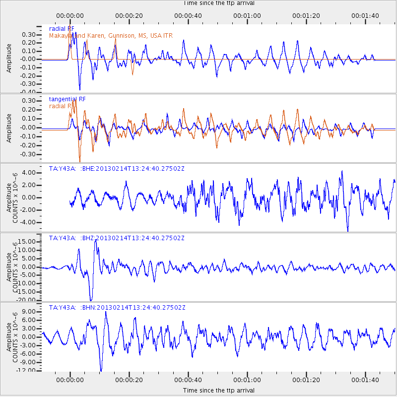
Signal To Noise
| Channel | StoN | STA | LTA |
| TA:Y43A: :BHZ:20130214T13:24:40.27502Z | 13.4561615 | 4.2187003E-6 | 3.1351436E-7 |
| TA:Y43A: :BHN:20130214T13:24:40.27502Z | 2.4321208 | 2.2641573E-6 | 9.309395E-7 |
| TA:Y43A: :BHE:20130214T13:24:40.27502Z | 0.6263927 | 6.0382706E-7 | 9.639753E-7 |
| Arrivals |
| Ps | 1.9 SECOND |
| PpPs | 6.0 SECOND |
| PsPs/PpSs | 8.0 SECOND |


