You are here: Home > Network List > TA - USArray Transportable Network (new EarthScope stations) Stations List
> Station Y41A Eaglette Bearden, AR, USA > Earthquake Result Viewer
Y41A Eaglette Bearden, AR, USA - Earthquake Result Viewer

| Earthquake location: |
Eastern Siberia, Russia |
| Earthquake latitude/longitude: |
67.6/142.5 |
| Earthquake time(UTC): |
2013/02/14 (045) 13:13:53 GMT |
| Earthquake Depth: |
11 km |
| Earthquake Magnitude: |
6.5 MB, 6.7 MS, 6.6 MW, 6.7 MW |
| Earthquake Catalog/Contributor: |
WHDF/NEIC |
|
| Network: |
TA USArray Transportable Network (new EarthScope stations) |
| Station: |
Y41A Eaglette Bearden, AR, USA |
| Lat/Lon: |
33.88 N/92.61 W |
| Elevation: |
99 m |
|
| Distance: |
70.7 deg |
| Az: |
46.312 deg |
| Baz: |
340.568 deg |
| Ray Param: |
0.054807883 |
| Estimated Moho Depth: |
12.5 km |
| Estimated Crust Vp/Vs: |
1.60 |
| Assumed Crust Vp: |
6.245 km/s |
| Estimated Crust Vs: |
3.903 km/s |
| Estimated Crust Poisson's Ratio: |
0.18 |
|
| Radial Match: |
89.72722 % |
| Radial Bump: |
400 |
| Transverse Match: |
83.21133 % |
| Transverse Bump: |
400 |
| SOD ConfigId: |
494114 |
| Insert Time: |
2013-05-04 05:54:59.677 +0000 |
| GWidth: |
2.5 |
| Max Bumps: |
400 |
| Tol: |
0.001 |
|
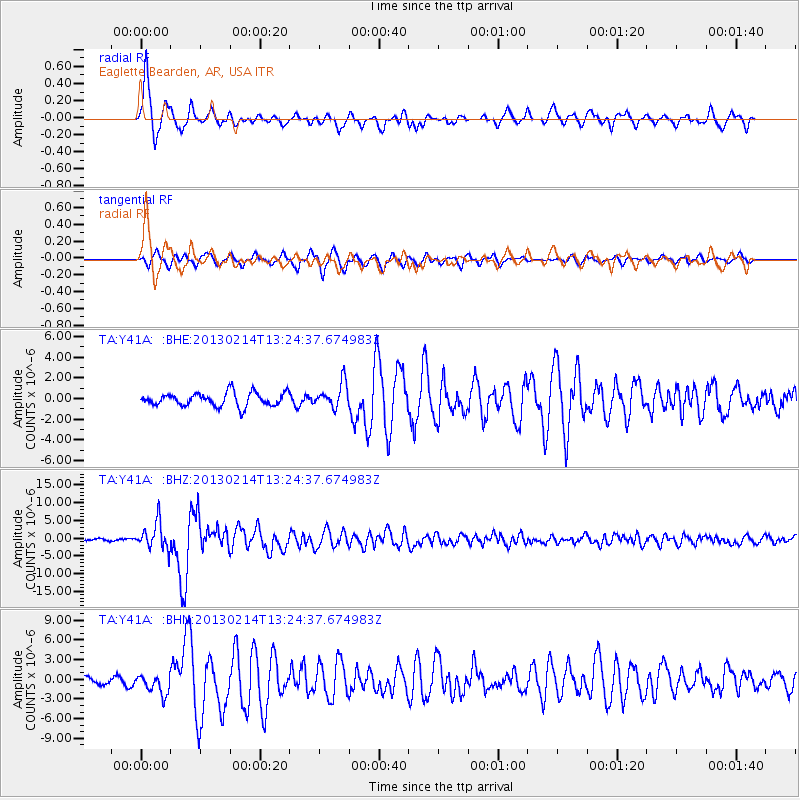
Signal To Noise
| Channel | StoN | STA | LTA |
| TA:Y41A: :BHZ:20130214T13:24:37.674983Z | 12.697224 | 3.7649288E-6 | 2.965159E-7 |
| TA:Y41A: :BHN:20130214T13:24:37.674983Z | 2.9583204 | 1.4790264E-6 | 4.999548E-7 |
| TA:Y41A: :BHE:20130214T13:24:37.674983Z | 1.8412293 | 1.1977133E-6 | 6.504966E-7 |
| Arrivals |
| Ps | 1.2 SECOND |
| PpPs | 5.0 SECOND |
| PsPs/PpSs | 6.3 SECOND |


