You are here: Home > Network List > TA - USArray Transportable Network (new EarthScope stations) Stations List
> Station M39A Webster, IA, USA > Earthquake Result Viewer
M39A Webster, IA, USA - Earthquake Result Viewer

| Earthquake location: |
Eastern Siberia, Russia |
| Earthquake latitude/longitude: |
67.6/142.5 |
| Earthquake time(UTC): |
2013/02/14 (045) 13:13:53 GMT |
| Earthquake Depth: |
11 km |
| Earthquake Magnitude: |
6.5 MB, 6.7 MS, 6.6 MW, 6.7 MW |
| Earthquake Catalog/Contributor: |
WHDF/NEIC |
|
| Network: |
TA USArray Transportable Network (new EarthScope stations) |
| Station: |
M39A Webster, IA, USA |
| Lat/Lon: |
41.48 N/92.17 W |
| Elevation: |
264 m |
|
| Distance: |
63.7 deg |
| Az: |
43.156 deg |
| Baz: |
339.609 deg |
| Ray Param: |
0.05941532 |
| Estimated Moho Depth: |
17.25 km |
| Estimated Crust Vp/Vs: |
1.91 |
| Assumed Crust Vp: |
6.498 km/s |
| Estimated Crust Vs: |
3.397 km/s |
| Estimated Crust Poisson's Ratio: |
0.31 |
|
| Radial Match: |
92.4506 % |
| Radial Bump: |
400 |
| Transverse Match: |
79.47122 % |
| Transverse Bump: |
400 |
| SOD ConfigId: |
494114 |
| Insert Time: |
2013-05-04 05:56:44.451 +0000 |
| GWidth: |
2.5 |
| Max Bumps: |
400 |
| Tol: |
0.001 |
|
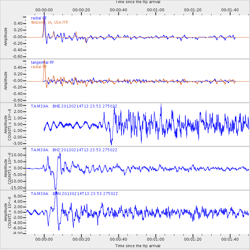
Signal To Noise
| Channel | StoN | STA | LTA |
| TA:M39A: :BHZ:20130214T13:23:53.27502Z | 11.91366 | 3.2353657E-6 | 2.7156773E-7 |
| TA:M39A: :BHN:20130214T13:23:53.27502Z | 4.878836 | 1.7118691E-6 | 3.5087652E-7 |
| TA:M39A: :BHE:20130214T13:23:53.27502Z | 1.8741114 | 6.2234466E-7 | 3.3207453E-7 |
| Arrivals |
| Ps | 2.5 SECOND |
| PpPs | 7.4 SECOND |
| PsPs/PpSs | 9.9 SECOND |


