You are here: Home > Network List > XD14 - Illuminating the architecture of the greater Mount St. Helens magmatic systems f Stations List
> Station MG05 "Mount St Helens, WA" > Earthquake Result Viewer
MG05 "Mount St Helens, WA" - Earthquake Result Viewer
| Earthquake location: |
Komandorskiye Ostrova Region |
| Earthquake latitude/longitude: |
55.3/166.9 |
| Earthquake time(UTC): |
2014/07/03 (184) 02:56:41 GMT |
| Earthquake Depth: |
23 km |
| Earthquake Magnitude: |
5.8 MWP |
| Earthquake Catalog/Contributor: |
NEIC PDE/NEIC COMCAT |
|
| Network: |
XD Illuminating the architecture of the greater Mount St. Helens magmatic systems f |
| Station: |
MG05 "Mount St Helens, WA" |
| Lat/Lon: |
46.31 N/122.34 W |
| Elevation: |
1283 m |
|
| Distance: |
43.8 deg |
| Az: |
71.027 deg |
| Baz: |
308.726 deg |
| Ray Param: |
0.07227618 |
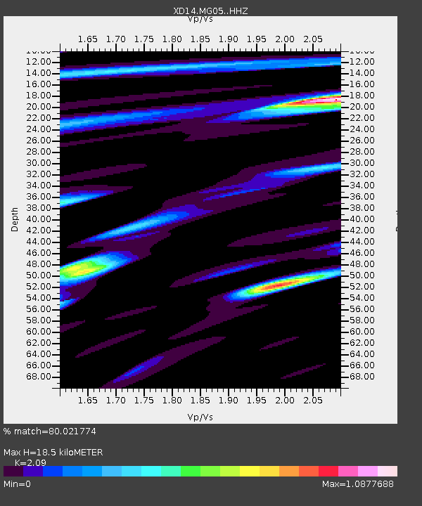
| Estimated Moho Depth: |
18.5 km |
| Estimated Crust Vp/Vs: |
2.09 |
| Assumed Crust Vp: |
6.566 km/s |
| Estimated Crust Vs: |
3.142 km/s |
| Estimated Crust Poisson's Ratio: |
0.35 |
|
| Radial Match: |
80.021774 % |
| Radial Bump: |
400 |
| Transverse Match: |
65.4266 % |
| Transverse Bump: |
400 |
| SOD ConfigId: |
3390531 |
| Insert Time: |
2019-04-12 15:55:59.338 +0000 |
| GWidth: |
2.5 |
| Max Bumps: |
400 |
| Tol: |
0.001 |
|

Signal To Noise
| Channel | StoN | STA | LTA |
| XD:MG05: :HHZ:20140703T03:04:13.684989Z | 8.747049 | 6.84203E-7 | 7.8221E-8 |
| XD:MG05: :HHN:20140703T03:04:13.684989Z | 3.5030744 | 2.8111438E-7 | 8.024791E-8 |
| XD:MG05: :HHE:20140703T03:04:13.684989Z | 3.7960262 | 4.055543E-7 | 1.0683653E-7 |
| Arrivals |
| Ps | 3.3 SECOND |
| PpPs | 8.2 SECOND |
| PsPs/PpSs | 11 SECOND |


