You are here: Home > Network List > TA - USArray Transportable Network (new EarthScope stations) Stations List
> Station F46A Macinaw City Comets, Mackinaw City, MI, USA > Earthquake Result Viewer
F46A Macinaw City Comets, Mackinaw City, MI, USA - Earthquake Result Viewer
| Earthquake location: |
Eastern Siberia, Russia |
| Earthquake latitude/longitude: |
67.6/142.5 |
| Earthquake time(UTC): |
2013/02/14 (045) 13:13:53 GMT |
| Earthquake Depth: |
11 km |
| Earthquake Magnitude: |
6.5 MB, 6.7 MS, 6.6 MW, 6.7 MW |
| Earthquake Catalog/Contributor: |
WHDF/NEIC |
|
| Network: |
TA USArray Transportable Network (new EarthScope stations) |
| Station: |
F46A Macinaw City Comets, Mackinaw City, MI, USA |
| Lat/Lon: |
45.77 N/84.76 W |
| Elevation: |
198 m |
|
| Distance: |
61.4 deg |
| Az: |
35.824 deg |
| Baz: |
341.332 deg |
| Ray Param: |
0.060869087 |
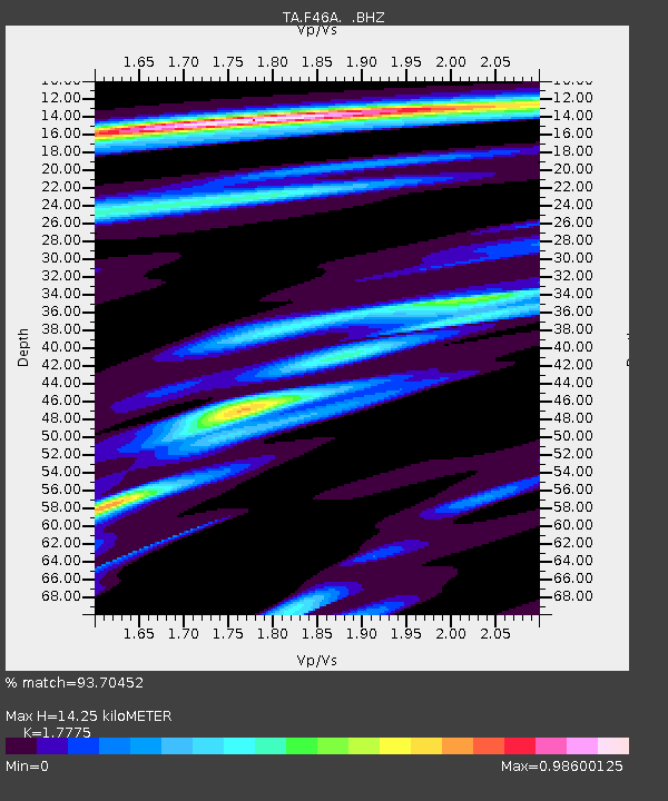
| Estimated Moho Depth: |
14.25 km |
| Estimated Crust Vp/Vs: |
1.78 |
| Assumed Crust Vp: |
6.483 km/s |
| Estimated Crust Vs: |
3.647 km/s |
| Estimated Crust Poisson's Ratio: |
0.27 |
|
| Radial Match: |
93.70452 % |
| Radial Bump: |
274 |
| Transverse Match: |
59.57938 % |
| Transverse Bump: |
400 |
| SOD ConfigId: |
494114 |
| Insert Time: |
2013-05-04 06:02:15.630 +0000 |
| GWidth: |
2.5 |
| Max Bumps: |
400 |
| Tol: |
0.001 |
|

Signal To Noise
| Channel | StoN | STA | LTA |
| TA:F46A: :BHZ:20130214T13:23:38.325007Z | 5.0591264 | 3.709898E-6 | 7.3330807E-7 |
| TA:F46A: :BHN:20130214T13:23:38.325007Z | 3.7472134 | 1.6425532E-6 | 4.3833992E-7 |
| TA:F46A: :BHE:20130214T13:23:38.325007Z | 1.8893508 | 1.0290576E-6 | 5.44662E-7 |
| Arrivals |
| Ps | 1.8 SECOND |
| PpPs | 5.8 SECOND |
| PsPs/PpSs | 7.6 SECOND |


