You are here: Home > Network List > TA - USArray Transportable Network (new EarthScope stations) Stations List
> Station K42A Prairie Point, Evansville, WI, USA > Earthquake Result Viewer
K42A Prairie Point, Evansville, WI, USA - Earthquake Result Viewer
| Earthquake location: |
Eastern Siberia, Russia |
| Earthquake latitude/longitude: |
67.6/142.5 |
| Earthquake time(UTC): |
2013/02/14 (045) 13:13:53 GMT |
| Earthquake Depth: |
11 km |
| Earthquake Magnitude: |
6.5 MB, 6.7 MS, 6.6 MW, 6.7 MW |
| Earthquake Catalog/Contributor: |
WHDF/NEIC |
|
| Network: |
TA USArray Transportable Network (new EarthScope stations) |
| Station: |
K42A Prairie Point, Evansville, WI, USA |
| Lat/Lon: |
42.78 N/89.35 W |
| Elevation: |
302 m |
|
| Distance: |
63.2 deg |
| Az: |
40.449 deg |
| Baz: |
340.288 deg |
| Ray Param: |
0.059738927 |
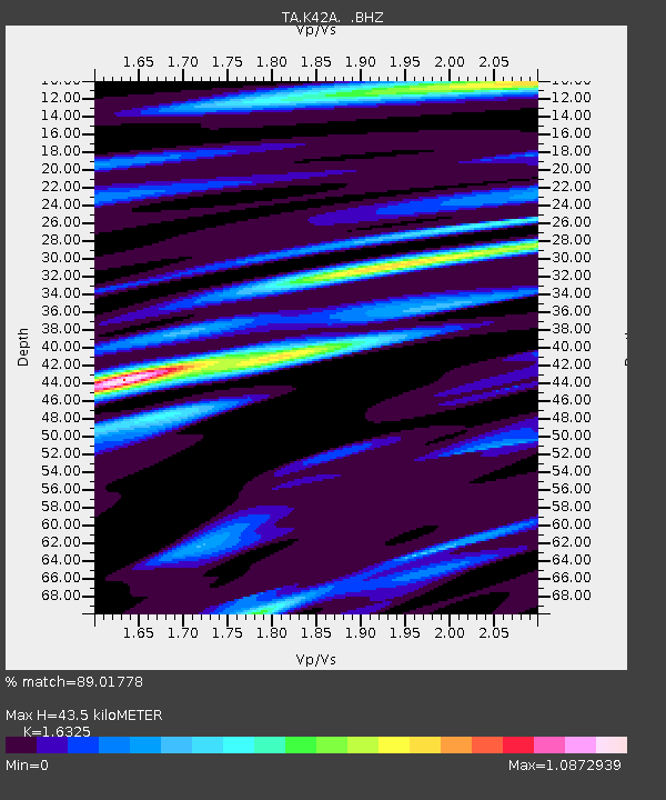
| Estimated Moho Depth: |
43.5 km |
| Estimated Crust Vp/Vs: |
1.63 |
| Assumed Crust Vp: |
6.571 km/s |
| Estimated Crust Vs: |
4.025 km/s |
| Estimated Crust Poisson's Ratio: |
0.20 |
|
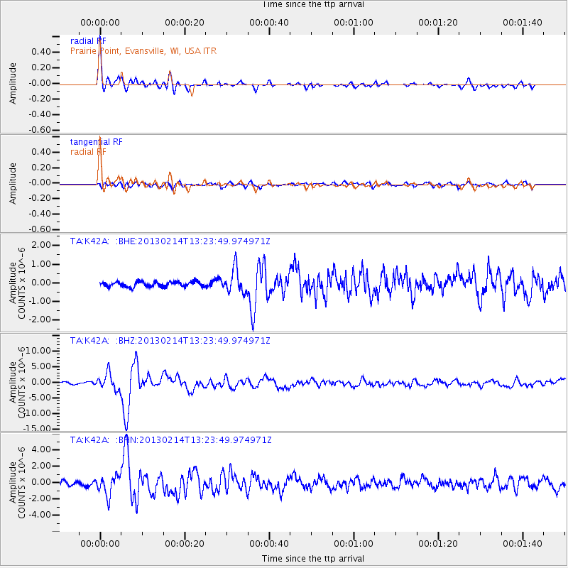
| Radial Match: |
89.01778 % |
| Radial Bump: |
400 |
| Transverse Match: |
72.028076 % |
| Transverse Bump: |
400 |
| SOD ConfigId: |
494114 |
| Insert Time: |
2013-05-04 06:02:36.678 +0000 |
| GWidth: |
2.5 |
| Max Bumps: |
400 |
| Tol: |
0.001 |
|
Signal To Noise
| Channel | StoN | STA | LTA |
| TA:K42A: :BHZ:20130214T13:23:49.974971Z | 6.8773913 | 2.698855E-6 | 3.9242423E-7 |
| TA:K42A: :BHN:20130214T13:23:49.974971Z | 2.6265426 | 1.213562E-6 | 4.620378E-7 |
| TA:K42A: :BHE:20130214T13:23:49.974971Z | 4.860084 | 6.561935E-7 | 1.350169E-7 |
| Arrivals |
| Ps | 4.4 SECOND |
| PpPs | 17 SECOND |
| PsPs/PpSs | 21 SECOND |


