You are here: Home > Network List > TA - USArray Transportable Network (new EarthScope stations) Stations List
> Station K43A Burlington, WI, USA > Earthquake Result Viewer
K43A Burlington, WI, USA - Earthquake Result Viewer
| Earthquake location: |
Eastern Siberia, Russia |
| Earthquake latitude/longitude: |
67.6/142.5 |
| Earthquake time(UTC): |
2013/02/14 (045) 13:13:53 GMT |
| Earthquake Depth: |
11 km |
| Earthquake Magnitude: |
6.5 MB, 6.7 MS, 6.6 MW, 6.7 MW |
| Earthquake Catalog/Contributor: |
WHDF/NEIC |
|
| Network: |
TA USArray Transportable Network (new EarthScope stations) |
| Station: |
K43A Burlington, WI, USA |
| Lat/Lon: |
42.70 N/88.33 W |
| Elevation: |
264 m |
|
| Distance: |
63.5 deg |
| Az: |
39.69 deg |
| Baz: |
340.633 deg |
| Ray Param: |
0.059531588 |
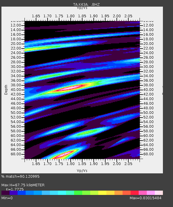
| Estimated Moho Depth: |
67.75 km |
| Estimated Crust Vp/Vs: |
1.77 |
| Assumed Crust Vp: |
6.571 km/s |
| Estimated Crust Vs: |
3.707 km/s |
| Estimated Crust Poisson's Ratio: |
0.27 |
|
| Radial Match: |
90.120995 % |
| Radial Bump: |
400 |
| Transverse Match: |
74.35619 % |
| Transverse Bump: |
400 |
| SOD ConfigId: |
494114 |
| Insert Time: |
2013-05-04 06:02:47.962 +0000 |
| GWidth: |
2.5 |
| Max Bumps: |
400 |
| Tol: |
0.001 |
|

Signal To Noise
| Channel | StoN | STA | LTA |
| TA:K43A: :BHZ:20130214T13:23:52.075007Z | 7.001551 | 2.7354363E-6 | 3.9069005E-7 |
| TA:K43A: :BHN:20130214T13:23:52.075007Z | 4.898098 | 1.3558689E-6 | 2.768154E-7 |
| TA:K43A: :BHE:20130214T13:23:52.075007Z | 1.6772776 | 6.985964E-7 | 4.1650617E-7 |
| Arrivals |
| Ps | 8.3 SECOND |
| PpPs | 27 SECOND |
| PsPs/PpSs | 36 SECOND |


