You are here: Home > Network List > TA - USArray Transportable Network (new EarthScope stations) Stations List
> Station S48A Wiedeman Farm, Cecilia, KY, USA > Earthquake Result Viewer
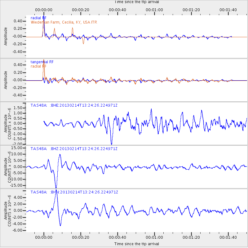
S48A Wiedeman Farm, Cecilia, KY, USA - Earthquake Result Viewer

| Earthquake location: |
Eastern Siberia, Russia |
| Earthquake latitude/longitude: |
67.6/142.5 |
| Earthquake time(UTC): |
2013/02/14 (045) 13:13:53 GMT |
| Earthquake Depth: |
11 km |
| Earthquake Magnitude: |
6.5 MB, 6.7 MS, 6.6 MW, 6.7 MW |
| Earthquake Catalog/Contributor: |
WHDF/NEIC |
|
| Network: |
TA USArray Transportable Network (new EarthScope stations) |
| Station: |
S48A Wiedeman Farm, Cecilia, KY, USA |
| Lat/Lon: |
37.66 N/86.06 W |
| Elevation: |
238 m |
|
| Distance: |
68.8 deg |
| Az: |
39.645 deg |
| Baz: |
342.079 deg |
| Ray Param: |
0.056040023 |
| Estimated Moho Depth: |
38.25 km |
| Estimated Crust Vp/Vs: |
1.73 |
| Assumed Crust Vp: |
6.444 km/s |
| Estimated Crust Vs: |
3.736 km/s |
| Estimated Crust Poisson's Ratio: |
0.25 |
|
| Radial Match: |
93.32775 % |
| Radial Bump: |
296 |
| Transverse Match: |
80.09746 % |
| Transverse Bump: |
400 |
| SOD ConfigId: |
494114 |
| Insert Time: |
2013-05-04 06:04:42.080 +0000 |
| GWidth: |
2.5 |
| Max Bumps: |
400 |
| Tol: |
0.001 |
|
Signal To Noise
| Channel | StoN | STA | LTA |
| TA:S48A: :BHZ:20130214T13:24:26.224971Z | 6.3246937 | 2.7307901E-6 | 4.3176635E-7 |
| TA:S48A: :BHN:20130214T13:24:26.224971Z | 3.4988995 | 8.2362385E-7 | 2.353951E-7 |
| TA:S48A: :BHE:20130214T13:24:26.224971Z | 2.841829 | 4.587687E-7 | 1.614343E-7 |
| Arrivals |
| Ps | 4.5 SECOND |
| PpPs | 16 SECOND |
| PsPs/PpSs | 20 SECOND |


