You are here: Home > Network List > TA - USArray Transportable Network (new EarthScope stations) Stations List
> Station W47A Westpoint, TN, USA > Earthquake Result Viewer
W47A Westpoint, TN, USA - Earthquake Result Viewer

| Earthquake location: |
Eastern Siberia, Russia |
| Earthquake latitude/longitude: |
67.6/142.5 |
| Earthquake time(UTC): |
2013/02/14 (045) 13:13:53 GMT |
| Earthquake Depth: |
11 km |
| Earthquake Magnitude: |
6.5 MB, 6.7 MS, 6.6 MW, 6.7 MW |
| Earthquake Catalog/Contributor: |
WHDF/NEIC |
|
| Network: |
TA USArray Transportable Network (new EarthScope stations) |
| Station: |
W47A Westpoint, TN, USA |
| Lat/Lon: |
35.25 N/87.59 W |
| Elevation: |
293 m |
|
| Distance: |
70.7 deg |
| Az: |
41.693 deg |
| Baz: |
341.877 deg |
| Ray Param: |
0.054781877 |
| Estimated Moho Depth: |
18.25 km |
| Estimated Crust Vp/Vs: |
1.77 |
| Assumed Crust Vp: |
6.476 km/s |
| Estimated Crust Vs: |
3.659 km/s |
| Estimated Crust Poisson's Ratio: |
0.27 |
|
| Radial Match: |
95.74779 % |
| Radial Bump: |
340 |
| Transverse Match: |
87.871544 % |
| Transverse Bump: |
400 |
| SOD ConfigId: |
494114 |
| Insert Time: |
2013-05-04 06:06:47.455 +0000 |
| GWidth: |
2.5 |
| Max Bumps: |
400 |
| Tol: |
0.001 |
|
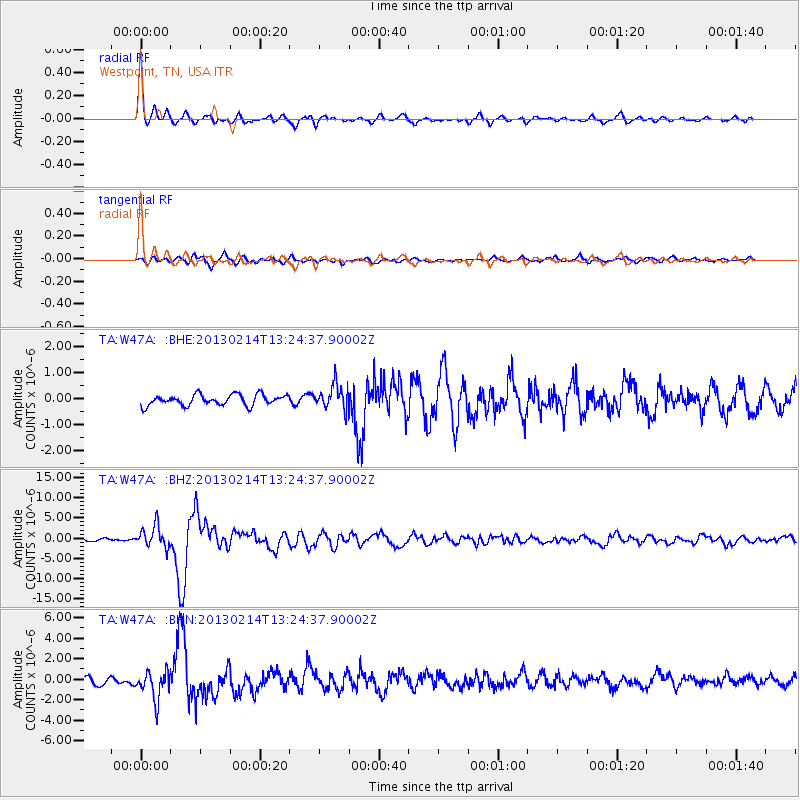
Signal To Noise
| Channel | StoN | STA | LTA |
| TA:W47A: :BHZ:20130214T13:24:37.90002Z | 8.703157 | 2.648963E-6 | 3.0436806E-7 |
| TA:W47A: :BHN:20130214T13:24:37.90002Z | 5.300697 | 1.3738968E-6 | 2.5919175E-7 |
| TA:W47A: :BHE:20130214T13:24:37.90002Z | 2.2607815 | 4.6030556E-7 | 2.0360463E-7 |
| Arrivals |
| Ps | 2.3 SECOND |
| PpPs | 7.5 SECOND |
| PsPs/PpSs | 9.8 SECOND |


