You are here: Home > Network List > GT - Global Telemetered Seismograph Network (USAF/USGS) Stations List
> Station BOSA Boshof, South Africa > Earthquake Result Viewer
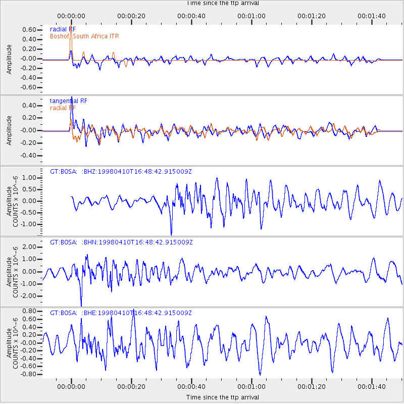
BOSA Boshof, South Africa - Earthquake Result Viewer
*The percent match for this event was below the threshold and hence no stack was calculated.
| Earthquake location: |
North Of Ascension Island |
| Earthquake latitude/longitude: |
-1.3/-15.7 |
| Earthquake time(UTC): |
1998/04/10 (100) 16:40:38 GMT |
| Earthquake Depth: |
10 km |
| Earthquake Magnitude: |
5.9 MS, 5.4 MB, 6.2 UNKNOWN, 6.1 MW |
| Earthquake Catalog/Contributor: |
WHDF/NEIC |
|
| Network: |
GT Global Telemetered Seismograph Network (USAF/USGS) |
| Station: |
BOSA Boshof, South Africa |
| Lat/Lon: |
28.61 S/25.26 E |
| Elevation: |
1280 m |
|
| Distance: |
47.5 deg |
| Az: |
128.69 deg |
| Baz: |
297.434 deg |
| Ray Param: |
$rayparam |
*The percent match for this event was below the threshold and hence was not used in the summary stack. |
|
| Radial Match: |
71.314095 % |
| Radial Bump: |
400 |
| Transverse Match: |
67.18603 % |
| Transverse Bump: |
400 |
| SOD ConfigId: |
4480 |
| Insert Time: |
2010-02-27 01:49:09.042 +0000 |
| GWidth: |
2.5 |
| Max Bumps: |
400 |
| Tol: |
0.001 |
|
Signal To Noise
| Channel | StoN | STA | LTA |
| GT:BOSA: :BHN:19980410T16:48:42.915009Z | 2.8724563 | 8.6687106E-7 | 3.0178737E-7 |
| GT:BOSA: :BHE:19980410T16:48:42.915009Z | 1.2830236 | 2.9293804E-7 | 2.2831851E-7 |
| GT:BOSA: :BHZ:19980410T16:48:42.915009Z | 3.0662875 | 4.6928793E-7 | 1.5304761E-7 |
| Arrivals |
| Ps | |
| PpPs | |
| PsPs/PpSs | |


