You are here: Home > Network List > TA - USArray Transportable Network (new EarthScope stations) Stations List
> Station 353A Camilla, GA, USA > Earthquake Result Viewer
353A Camilla, GA, USA - Earthquake Result Viewer
| Earthquake location: |
Eastern Siberia, Russia |
| Earthquake latitude/longitude: |
67.6/142.5 |
| Earthquake time(UTC): |
2013/02/14 (045) 13:13:53 GMT |
| Earthquake Depth: |
11 km |
| Earthquake Magnitude: |
6.5 MB, 6.7 MS, 6.6 MW, 6.7 MW |
| Earthquake Catalog/Contributor: |
WHDF/NEIC |
|
| Network: |
TA USArray Transportable Network (new EarthScope stations) |
| Station: |
353A Camilla, GA, USA |
| Lat/Lon: |
31.35 N/84.22 W |
| Elevation: |
54 m |
|
| Distance: |
75.3 deg |
| Az: |
40.091 deg |
| Baz: |
343.255 deg |
| Ray Param: |
0.05176098 |
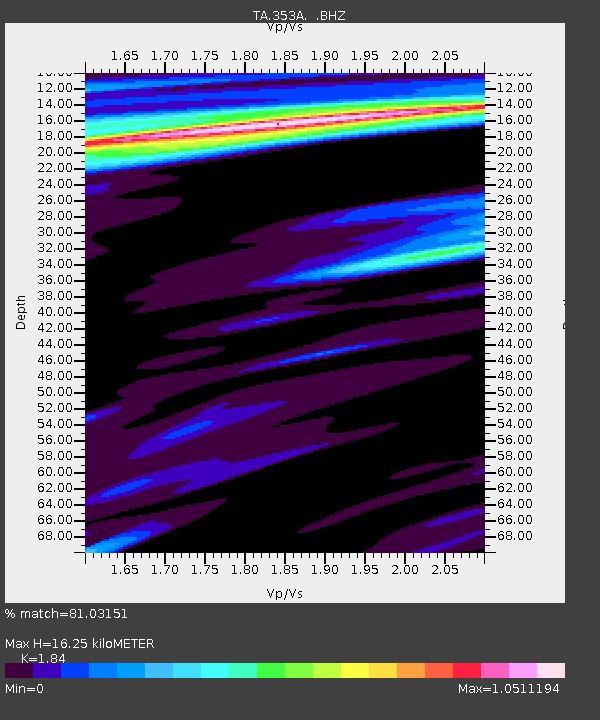
| Estimated Moho Depth: |
16.25 km |
| Estimated Crust Vp/Vs: |
1.84 |
| Assumed Crust Vp: |
6.347 km/s |
| Estimated Crust Vs: |
3.449 km/s |
| Estimated Crust Poisson's Ratio: |
0.29 |
|
| Radial Match: |
81.03151 % |
| Radial Bump: |
400 |
| Transverse Match: |
75.17265 % |
| Transverse Bump: |
371 |
| SOD ConfigId: |
494114 |
| Insert Time: |
2013-05-04 06:09:27.238 +0000 |
| GWidth: |
2.5 |
| Max Bumps: |
400 |
| Tol: |
0.001 |
|
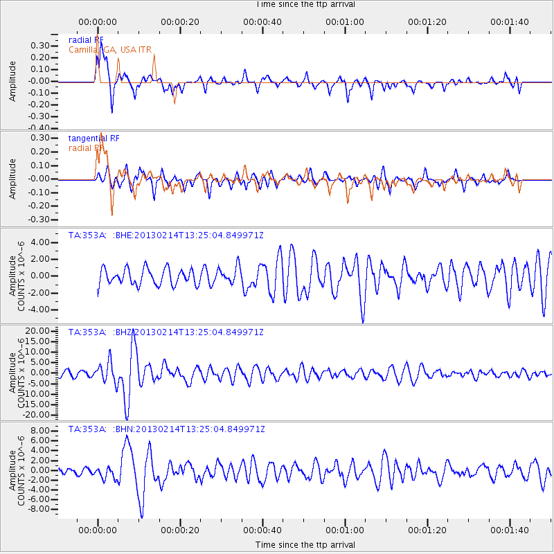
Signal To Noise
| Channel | StoN | STA | LTA |
| TA:353A: :BHZ:20130214T13:25:04.849971Z | 4.039465 | 4.946372E-6 | 1.2245117E-6 |
| TA:353A: :BHN:20130214T13:25:04.849971Z | 1.3836992 | 1.1613516E-6 | 8.3930934E-7 |
| TA:353A: :BHE:20130214T13:25:04.849971Z | 1.0733639 | 1.0059453E-6 | 9.3718944E-7 |
| Arrivals |
| Ps | 2.2 SECOND |
| PpPs | 7.1 SECOND |
| PsPs/PpSs | 9.3 SECOND |


