You are here: Home > Network List > TA - USArray Transportable Network (new EarthScope stations) Stations List
> Station W49A Belvidere, TN, USA > Earthquake Result Viewer
W49A Belvidere, TN, USA - Earthquake Result Viewer
| Earthquake location: |
Eastern Siberia, Russia |
| Earthquake latitude/longitude: |
67.6/142.5 |
| Earthquake time(UTC): |
2013/02/14 (045) 13:13:53 GMT |
| Earthquake Depth: |
11 km |
| Earthquake Magnitude: |
6.5 MB, 6.7 MS, 6.6 MW, 6.7 MW |
| Earthquake Catalog/Contributor: |
WHDF/NEIC |
|
| Network: |
TA USArray Transportable Network (new EarthScope stations) |
| Station: |
W49A Belvidere, TN, USA |
| Lat/Lon: |
35.12 N/86.26 W |
| Elevation: |
251 m |
|
| Distance: |
71.2 deg |
| Az: |
40.64 deg |
| Baz: |
342.296 deg |
| Ray Param: |
0.054480698 |
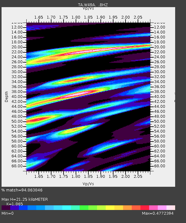
| Estimated Moho Depth: |
21.25 km |
| Estimated Crust Vp/Vs: |
1.87 |
| Assumed Crust Vp: |
6.476 km/s |
| Estimated Crust Vs: |
3.472 km/s |
| Estimated Crust Poisson's Ratio: |
0.30 |
|
| Radial Match: |
94.863846 % |
| Radial Bump: |
338 |
| Transverse Match: |
79.35976 % |
| Transverse Bump: |
400 |
| SOD ConfigId: |
494114 |
| Insert Time: |
2013-05-04 06:11:52.884 +0000 |
| GWidth: |
2.5 |
| Max Bumps: |
400 |
| Tol: |
0.001 |
|
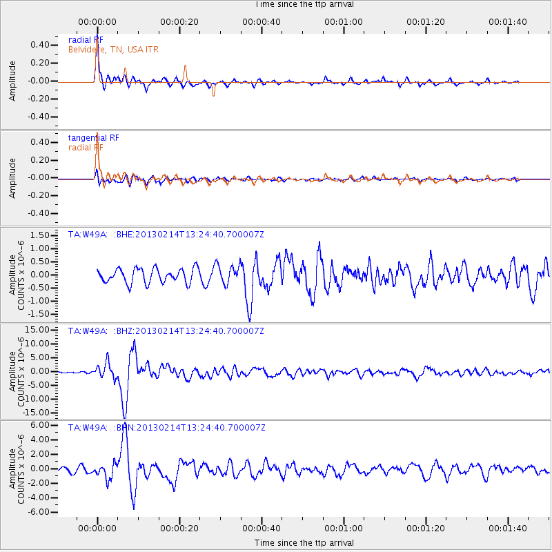
Signal To Noise
| Channel | StoN | STA | LTA |
| TA:W49A: :BHZ:20130214T13:24:40.700007Z | 12.411354 | 2.7727397E-6 | 2.2340348E-7 |
| TA:W49A: :BHN:20130214T13:24:40.700007Z | 3.8081138 | 1.0254587E-6 | 2.6928257E-7 |
| TA:W49A: :BHE:20130214T13:24:40.700007Z | 1.2839447 | 3.4740057E-7 | 2.7057283E-7 |
| Arrivals |
| Ps | 2.9 SECOND |
| PpPs | 9.1 SECOND |
| PsPs/PpSs | 12 SECOND |


