You are here: Home > Network List > TA - USArray Transportable Network (new EarthScope stations) Stations List
> Station S52A Salyersville, KY, USA > Earthquake Result Viewer
S52A Salyersville, KY, USA - Earthquake Result Viewer
| Earthquake location: |
Eastern Siberia, Russia |
| Earthquake latitude/longitude: |
67.6/142.5 |
| Earthquake time(UTC): |
2013/02/14 (045) 13:13:53 GMT |
| Earthquake Depth: |
11 km |
| Earthquake Magnitude: |
6.5 MB, 6.7 MS, 6.6 MW, 6.7 MW |
| Earthquake Catalog/Contributor: |
WHDF/NEIC |
|
| Network: |
TA USArray Transportable Network (new EarthScope stations) |
| Station: |
S52A Salyersville, KY, USA |
| Lat/Lon: |
37.68 N/83.08 W |
| Elevation: |
367 m |
|
| Distance: |
69.5 deg |
| Az: |
37.226 deg |
| Baz: |
343.032 deg |
| Ray Param: |
0.055587057 |
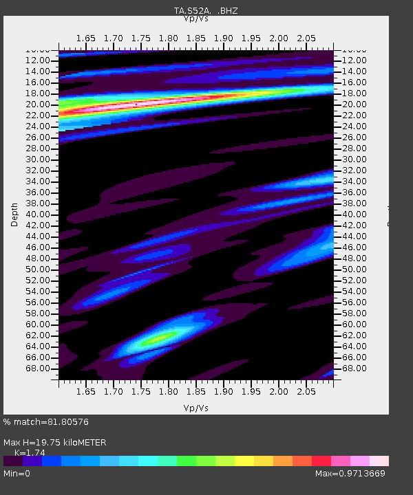
| Estimated Moho Depth: |
19.75 km |
| Estimated Crust Vp/Vs: |
1.74 |
| Assumed Crust Vp: |
6.476 km/s |
| Estimated Crust Vs: |
3.722 km/s |
| Estimated Crust Poisson's Ratio: |
0.25 |
|
| Radial Match: |
81.80576 % |
| Radial Bump: |
386 |
| Transverse Match: |
68.78077 % |
| Transverse Bump: |
377 |
| SOD ConfigId: |
494114 |
| Insert Time: |
2013-05-04 06:12:34.431 +0000 |
| GWidth: |
2.5 |
| Max Bumps: |
400 |
| Tol: |
0.001 |
|
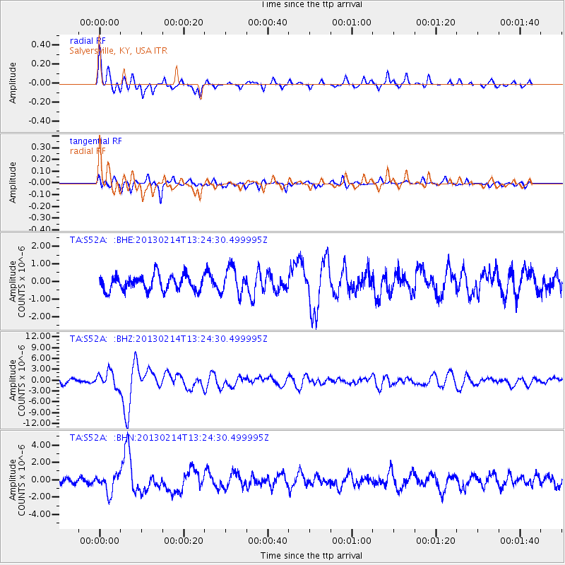
Signal To Noise
| Channel | StoN | STA | LTA |
| TA:S52A: :BHZ:20130214T13:24:30.499995Z | 2.289082 | 2.2628565E-6 | 9.885432E-7 |
| TA:S52A: :BHN:20130214T13:24:30.499995Z | 2.3847134 | 1.0818541E-6 | 4.5366207E-7 |
| TA:S52A: :BHE:20130214T13:24:30.499995Z | 1.7318603 | 7.3913384E-7 | 4.2678607E-7 |
| Arrivals |
| Ps | 2.3 SECOND |
| PpPs | 8.0 SECOND |
| PsPs/PpSs | 10 SECOND |


